Washington Heights geodata
Washington Heights (New York) is a populated place; located in United States in America/New_York (GMT-4) time zone. With population of 152,613 people, there are 188 cities with bigger population in this country. Compared to other cities in United States, 64% of cities are located further ↓South; 91% of cities are located further ←West and 76.9% of cities have higher elevation than Washington Heights. Note1


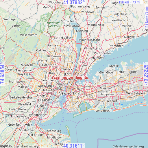
Washington Heights GPS coordinates[2]
40° 51' 0.36" North, 73° 56' 7.476" West
| Map corner | latitude | longitude |
|---|---|---|
| Upper-left | 41.37982°, | -74.63854° |
| Center: | 40.8501°, | -73.93541° |
| Lower-right: | 40.31611°, | -73.23229° |
| Map W x H: | 118.3×118.3 km | = 73.5×73.5mi |
| max Lat: | 71.29058° ⇑36% North |
| Washington Heights: | 40.8501° |
| min Lat: | ⇓64% South 19.06759° |
| min Long | Washington Heig | max Long |
| -171.73463° | -73.93541° | -66.98998° |
| W 91%⇐ | ⇒9% E |
Elevation
Elevation of Washington Heights is 61 m = 200 ft, and this is 233.8 m = 767 ft below average elevation for this country.
| Max E: |
3189 m = 10463 ft | 76.9% |
| Avg. | 294.8 m = 967 ft | |
| Washington Heights | 61 m = 200 ft | |
Min E: |
-60 m = -197 ft | 23.1% |
See also: Washington Heights elevation on elevation.city.
Geographical zone
Washington Heights is located in North temperate zone (between Tropic of Cancer and the Arctic Circle). Distance of this Northern Tropic circle is 1936.2 km =1203.1 mi to South.| Distance of | km | miles | from Washington Heights |
|---|---|---|---|
| North Pole | 5465 | 3395.8 | to North |
| Arctic Circle | 2859.1 | 1776.6 | to North |
| Tropic Cancer | 1936.2 | 1203.1 | to South |
| Equator | 4542.1 | 2822.3 | to South |


Nearby cities:
15 places around Washington Heights: (largest is in red/bold)
• East Tremont
3.8 km =2.4 mi,  97°
97°
• Edgewater
4.2 km =2.6 mi,  232°
232°
• Englewood Cliffs
4.2 km =2.6 mi,  340°
340°
• Fordham
3.3 km =2.1 mi,  71°
71°
• Fort Lee
2.9 km =1.8 mi,  271°
271°
• Inwood
1.9 km =1.2 mi,  22°
22°
• Kings Bridge
4.1 km =2.5 mi,  38°
38°
• Leonia
4.6 km =2.9 mi,  285°
285°
• Melrose
3.5 km =2.2 mi,  143°
143°
• Morris Heights
1.3 km =0.8 mi,  91°
91°
• Morrisania
3.4 km =2.1 mi,  133°
133°
• Mott Haven
4.7 km =2.9 mi,  167°
167°
• Spuyten Duyvil
3.8 km =2.4 mi, 23°
• Tremont
2.5 km =1.6 mi, 91°
• University Heights
2.5 km =1.6 mi,  63°
63°
Sources, notices
• [Note1] Compared only with cities in United States existing in our database
• [Src1] Map data: © OpenStreetMap contributors (CC-BY-SA)
• [Src2] Other city data from geonames.org with taken over terms of usage.
• [Src3] Geographical zone / Annual Mean Temperature by Robert A. Rohde @ Wikipedia
