Fordham geodata
Fordham (New York) is a populated place; located in United States in America/New_York (GMT-4) time zone. With population of 94,678 people, there are 379 cities with bigger population in this country. Compared to other cities in United States, 64.1% of cities are located further ↓South; 91.2% of cities are located further ←West and 81.1% of cities have higher elevation than Fordham. Note1


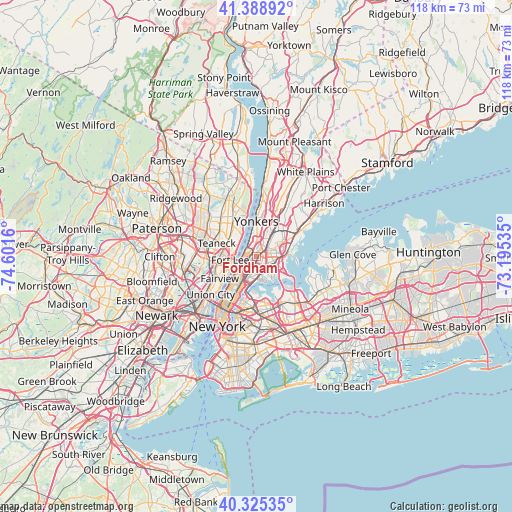
Fordham GPS coordinates[2]
40° 51' 33.372" North, 73° 53' 54.492" West
| Map corner | latitude | longitude |
|---|---|---|
| Upper-left | 41.38892°, | -74.6016° |
| Center: | 40.85927°, | -73.89847° |
| Lower-right: | 40.32535°, | -73.19535° |
| Map W x H: | 118.3×118.3 km | = 73.5×73.5mi |
| max Lat: | 71.29058° ⇑35.9% North |
| Fordham: | 40.85927° |
| min Lat: | ⇓64.1% South 19.06759° |
| min Long | Fordham | max Long |
| -171.73463° | -73.89847° | -66.98998° |
| W 91.2%⇐ | ⇒8.8% E |
Elevation
Elevation of Fordham is 42 m = 138 ft, and this is 252.8 m = 829 ft below average elevation for this country.
| Max E: |
3189 m = 10463 ft | 81.1% |
| Avg. | 294.8 m = 967 ft | |
| Fordham | 42 m = 138 ft | |
Min E: |
-60 m = -197 ft | 18.9% |
See also: Fordham elevation on elevation.city.
Geographical zone
Fordham is located in North temperate zone (between Tropic of Cancer and the Arctic Circle). Distance of this Northern Tropic circle is 1937.2 km =1203.7 mi to South.| Distance of | km | miles | from Fordham |
|---|---|---|---|
| North Pole | 5463.9 | 3395.1 | to North |
| Arctic Circle | 2858 | 1775.9 | to North |
| Tropic Cancer | 1937.2 | 1203.7 | to South |
| Equator | 4543.1 | 2823 | to South |


Nearby cities:
15 places around Fordham: (largest is in red/bold)
• East Tremont
1.7 km =1.1 mi,  157°
157°
• Inwood
2.5 km =1.6 mi,  286°
286°
• Kings Bridge
2.2 km =1.4 mi,  345°
345°
• Melrose
4 km =2.5 mi,  194°
194°
• Morris Heights
2.1 km =1.3 mi,  239°
239°
• Morris Park
3.9 km =2.4 mi,  101°
101°
• Morrisania
3.4 km =2.1 mi, 191°
• Parkchester
3.9 km =2.4 mi,  125°
125°
• Spuyten Duyvil
2.9 km =1.8 mi,  326°
326°
• The Bronx
2.9 km =1.8 mi,  111°
111°
• Tremont
1.2 km =0.7 mi,  209°
209°
• University Heights
0.9 km =0.6 mi,  275°
275°
• Van Nest
3.2 km =2 mi, 112°
• Washington Heights
3.3 km =2.1 mi,  251°
251°
• West Farms
2.8 km =1.7 mi,  140°
140°
Sources, notices
• [Note1] Compared only with cities in United States existing in our database
• [Src1] Map data: © OpenStreetMap contributors (CC-BY-SA)
• [Src2] Other city data from geonames.org with taken over terms of usage.
• [Src3] Geographical zone / Annual Mean Temperature by Robert A. Rohde @ Wikipedia
