West Hempstead geodata
West Hempstead (New York) is a populated place; located in United States in America/New_York (GMT-4) time zone. With population of 18,862 people, there are 2673 cities with bigger population in this country. Compared to other cities in United States, 61.6% of cities are located further ↓South; 92.4% of cities are located further ←West and 87.8% of cities have higher elevation than West Hempstead. Note1


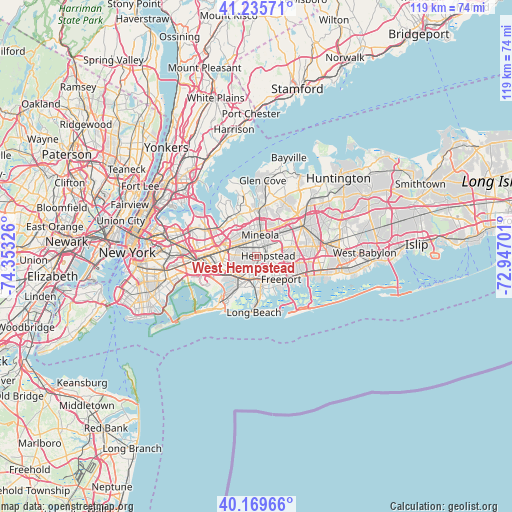
West Hempstead GPS coordinates[2]
40° 42' 17.352" North, 73° 39' 0.468" West
| Map corner | latitude | longitude |
|---|---|---|
| Upper-left | 41.23571°, | -74.35326° |
| Center: | 40.70482°, | -73.65013° |
| Lower-right: | 40.16966°, | -72.94701° |
| Map W x H: | 118.5×118.5 km | = 73.6×73.6mi |
| max Lat: | 71.29058° ⇑38.4% North |
| West Hempstead: | 40.70482° |
| min Lat: | ⇓61.6% South 19.06759° |
| min Long | West Hempstead | max Long |
| -171.73463° | -73.65013° | -66.98998° |
| W 92.4%⇐ | ⇒7.6% E |
Elevation
Elevation of West Hempstead is 21 m = 69 ft, and this is 273.8 m = 898 ft below average elevation for this country.
| Max E: |
3189 m = 10463 ft | 87.8% |
| Avg. | 294.8 m = 967 ft | |
| West Hempstead | 21 m = 69 ft | |
Min E: |
-60 m = -197 ft | 12.2% |
See also: United States elevation on elevation.city.
Geographical zone
West Hempstead is located in North temperate zone (between Tropic of Cancer and the Arctic Circle). Distance of this Northern Tropic circle is 1920 km =1193 mi to South.| Distance of | km | miles | from West Hempstead |
|---|---|---|---|
| North Pole | 5481.1 | 3405.8 | to North |
| Arctic Circle | 2875.2 | 1786.6 | to North |
| Tropic Cancer | 1920 | 1193 | to South |
| Equator | 4526 | 2812.3 | to South |


Nearby cities:
15 places around West Hempstead: (largest is in red/bold)
• Floral Park
5.1 km =3.2 mi,  294°
294°
• Franklin Square
2.2 km =1.4 mi,  277°
277°
• Garden City
2.8 km =1.7 mi,  28°
28°
• Garden City Park
4.2 km =2.6 mi,  345°
345°
• Garden City South
1.2 km =0.7 mi,  312°
312°
• Hempstead
2.7 km =1.7 mi,  86°
86°
• Lakeview
2.2 km =1.4 mi,  185°
185°
• Malverne
3.5 km =2.2 mi,  215°
215°
• Mineola
5 km =3.1 mi,  9°
9°
• New Hyde Park
4.6 km =2.9 mi,  316°
316°
• North Valley Stream
4.9 km =3 mi,  243°
243°
• South Floral Park
4.3 km =2.7 mi, 284°
• South Hempstead
4 km =2.5 mi,  132°
132°
• Stewart Manor
3.6 km =2.2 mi,  296°
296°
• Uniondale
4.8 km =3 mi,  95°
95°
Sources, notices
• [Note1] Compared only with cities in United States existing in our database
• [Src1] Map data: © OpenStreetMap contributors (CC-BY-SA)
• [Src2] Other city data from geonames.org with taken over terms of usage.
• [Src3] Geographical zone / Annual Mean Temperature by Robert A. Rohde @ Wikipedia
