Archbold geodata
Archbold (Ohio) is a populated place; located in United States in America/New_York (GMT-4) time zone. With population of 4,341 people, there are 7822 cities with bigger population in this country. Compared to other cities in United States, 71.1% of cities are located further ↓South; 58.2% of cities are located further ←West and 56.1% of cities have lower elevation than Archbold. Note1


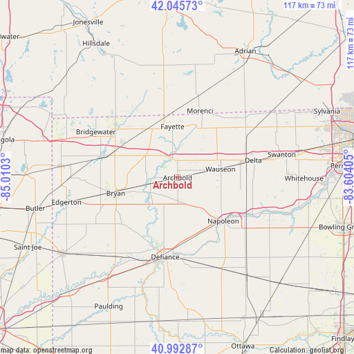
Archbold GPS coordinates[2]
41° 31' 17.184" North, 84° 18' 25.812" West
| Map corner | latitude | longitude |
|---|---|---|
| Upper-left | 42.04573°, | -85.0103° |
| Center: | 41.52144°, | -84.30717° |
| Lower-right: | 40.99287°, | -83.60405° |
| Map W x H: | 117.1×117.1 km | = 72.8×72.8mi |
| max Lat: | 71.29058° ⇑28.9% North |
| Archbold: | 41.52144° |
| min Lat: | ⇓71.1% South 19.06759° |
| min Long | Archbold | max Long |
| -171.73463° | -84.30717° | -66.98998° |
| W 58.2%⇐ | ⇒41.8% E |
Elevation
Elevation of Archbold is 223 m = 732 ft, and this is 71.8 m = 236 ft below average elevation for this country.
| Max E: |
3189 m = 10463 ft | 43.9% |
| Avg. | 294.8 m = 967 ft | |
| Archbold | 223 m = 732 ft | |
Min E: |
-60 m = -197 ft | 56.1% |
See also: United States elevation on elevation.city.
Geographical zone
Archbold is located in North temperate zone (between Tropic of Cancer and the Arctic Circle). Distance of this Northern Tropic circle is 2010.8 km =1249.5 mi to South.| Distance of | km | miles | from Archbold |
|---|---|---|---|
| North Pole | 5390.3 | 3349.4 | to North |
| Arctic Circle | 2784.4 | 1730.1 | to North |
| Tropic Cancer | 2010.8 | 1249.5 | to South |
| Equator | 4616.8 | 2868.7 | to South |


Nearby cities:
15 places around Archbold: (largest is in red/bold)
• Bryan
21.1 km =13.1 mi,  255°
255°
• Burlington
5.7 km =3.5 mi,  359°
359°
• Defiance
26.7 km =16.6 mi,  188°
188°
• Delta
25.8 km =16 mi,  76°
76°
• Fayette
17 km =10.6 mi,  354°
354°
• Liberty Center
26.3 km =16.3 mi,  109°
109°
• Lyons
27.9 km =17.3 mi,  44°
44°
• Montpelier
25.8 km =16 mi,  285°
285°
• Morenci
23.2 km =14.4 mi,  18°
18°
• Napoleon
20.9 km =13 mi,  133°
133°
• Pioneer
27 km =16.8 mi,  310°
310°
• Stryker
9.1 km =5.7 mi, 257°
• Waldron
24.8 km =15.4 mi,  337°
337°
• Wauseon
14.1 km =8.8 mi, 77°
• West Unity
12.8 km =8 mi,  304°
304°
Sources, notices
• [Note1] Compared only with cities in United States existing in our database
• [Src1] Map data: © OpenStreetMap contributors (CC-BY-SA)
• [Src2] Other city data from geonames.org with taken over terms of usage.
• [Src3] Geographical zone / Annual Mean Temperature by Robert A. Rohde @ Wikipedia
