Bryan geodata
Bryan (Ohio) is a seat of a second-order administrative division; located in United States in America/New_York (GMT-4) time zone. With population of 8,436 people, there are 5057 cities with bigger population in this country. Compared to other cities in United States, 70.6% of cities are located further ↓South; 57.2% of cities are located further ←West and 58.8% of cities have lower elevation than Bryan. Note1


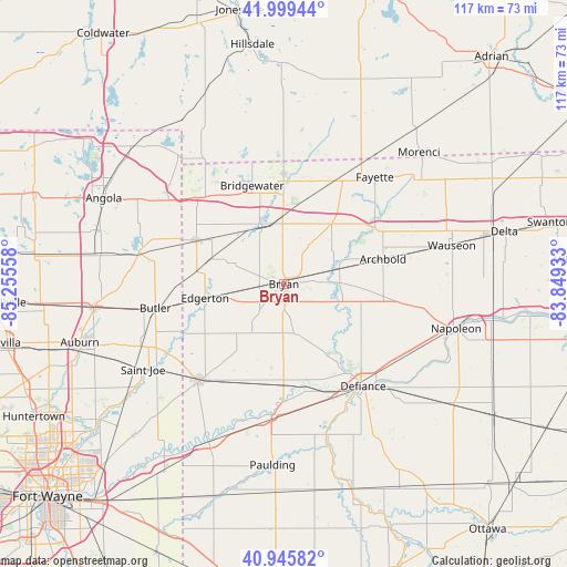
Bryan GPS coordinates[2]
41° 28' 29.172" North, 84° 33' 8.82" West
| Map corner | latitude | longitude |
|---|---|---|
| Upper-left | 41.99944°, | -85.25558° |
| Center: | 41.47477°, | -84.55245° |
| Lower-right: | 40.94582°, | -83.84933° |
| Map W x H: | 117.2×117.2 km | = 72.8×72.8mi |
| max Lat: | 71.29058° ⇑29.4% North |
| Bryan: | 41.47477° |
| min Lat: | ⇓70.6% South 19.06759° |
| min Long | Bryan | max Long |
| -171.73463° | -84.55245° | -66.98998° |
| W 57.2%⇐ | ⇒42.8% E |
Elevation
Elevation of Bryan is 234 m = 768 ft, and this is 60.8 m = 199 ft below average elevation for this country.
| Max E: |
3189 m = 10463 ft | 41.2% |
| Avg. | 294.8 m = 967 ft | |
| Bryan | 234 m = 768 ft | |
Min E: |
-60 m = -197 ft | 58.8% |
See also: United States elevation on elevation.city.
Geographical zone
Bryan is located in North temperate zone (between Tropic of Cancer and the Arctic Circle). Distance of this Northern Tropic circle is 2005.6 km =1246.2 mi to South.| Distance of | km | miles | from Bryan |
|---|---|---|---|
| North Pole | 5395.5 | 3352.6 | to North |
| Arctic Circle | 2789.6 | 1733.4 | to North |
| Tropic Cancer | 2005.6 | 1246.2 | to South |
| Equator | 4611.6 | 2865.5 | to South |


Nearby cities:
15 places around Bryan: (largest is in red/bold)
• Archbold
21.1 km =13.1 mi,  75°
75°
• Burlington
23.1 km =14.4 mi,  61°
61°
• Butler
27 km =16.8 mi,  259°
259°
• Defiance
26.8 km =16.7 mi,  142°
142°
• Edgerton
16.6 km =10.3 mi, 259°
• Edon
20.2 km =12.6 mi,  296°
296°
• Fayette
29 km =18 mi,  40°
40°
• Hamilton
30.7 km =19.1 mi,  282°
282°
• Hicksville
26.7 km =16.6 mi,  220°
220°
• Montpelier
13 km =8.1 mi,  340°
340°
• Pioneer
22.8 km =14.2 mi,  359°
359°
• Sherwood
20.8 km =12.9 mi,  180°
180°
• Stryker
12 km =7.5 mi,  74°
74°
• Waldron
30.3 km =18.8 mi,  21°
21°
• West Unity
15.8 km =9.8 mi, 38°
Sources, notices
• [Note1] Compared only with cities in United States existing in our database
• [Src1] Map data: © OpenStreetMap contributors (CC-BY-SA)
• [Src2] Other city data from geonames.org with taken over terms of usage.
• [Src3] Geographical zone / Annual Mean Temperature by Robert A. Rohde @ Wikipedia
