Aurora geodata
Aurora (Ohio) is a populated place; located in United States in America/New_York (GMT-4) time zone. With population of 15,838 people, there are 3093 cities with bigger population in this country. Compared to other cities in United States, 69% of cities are located further ↓South; 68.4% of cities are located further ←West and 78.7% of cities have lower elevation than Aurora. Note1


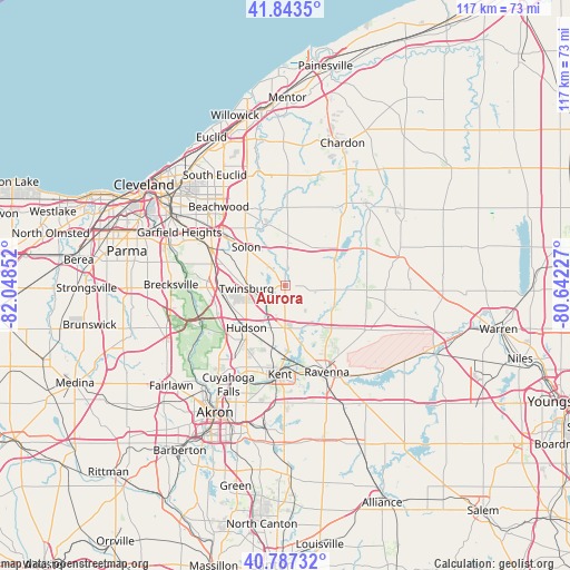
Aurora GPS coordinates[2]
41° 19' 3.18" North, 81° 20' 43.404" West
| Map corner | latitude | longitude |
|---|---|---|
| Upper-left | 41.8435°, | -82.04852° |
| Center: | 41.31755°, | -81.34539° |
| Lower-right: | 40.78732°, | -80.64227° |
| Map W x H: | 117.4×117.4 km | = 72.9×72.9mi |
| max Lat: | 71.29058° ⇑31% North |
| Aurora: | 41.31755° |
| min Lat: | ⇓69% South 19.06759° |
| min Long | Aurora | max Long |
| -171.73463° | -81.34539° | -66.98998° |
| W 68.4%⇐ | ⇒31.6% E |
Elevation
Elevation of Aurora is 342 m = 1122 ft, and this is 47.2 m = 155 ft above average elevation for this country.
| Max E: |
3189 m = 10463 ft | 21.3% |
| Aurora | 342 m 1122 ft | |
| Avg. | 294.8 m = 967 ft | |
Min E: |
-60 m = -197 ft | 78.7% |
See also: United States elevation on elevation.city.
Geographical zone
Aurora is located in North temperate zone (between Tropic of Cancer and the Arctic Circle). Distance of this Northern Tropic circle is 1988.2 km =1235.4 mi to South.| Distance of | km | miles | from Aurora |
|---|---|---|---|
| North Pole | 5413 | 3363.5 | to North |
| Arctic Circle | 2807.1 | 1744.3 | to North |
| Tropic Cancer | 1988.2 | 1235.4 | to South |
| Equator | 4594.1 | 2854.6 | to South |


Nearby cities:
15 places around Aurora: (largest is in red/bold)
• Bainbridge
7.7 km =4.8 mi,  3°
3°
• Bentleyville
12 km =7.5 mi,  332°
332°
• Boston Heights
15.2 km =9.4 mi,  247°
247°
• Chagrin Falls
13.6 km =8.5 mi,  345°
345°
• Glenwillow
11.5 km =7.1 mi,  295°
295°
• Hudson
11.7 km =7.3 mi,  222°
222°
• Macedonia
13.6 km =8.5 mi,  268°
268°
• Mantua
10.8 km =6.7 mi,  110°
110°
• Oakwood
14.6 km =9.1 mi,  291°
291°
• Reminderville
5.2 km =3.2 mi,  307°
307°
• Solon
11.3 km =7 mi,  315°
315°
• South Russell
12.8 km =8 mi, 352°
• Streetsboro
8.7 km =5.4 mi,  180°
180°
• Twinsburg
7.9 km =4.9 mi, 265°
• Twinsburg Heights
9.6 km =6 mi,  262°
262°
Sources, notices
• [Note1] Compared only with cities in United States existing in our database
• [Src1] Map data: © OpenStreetMap contributors (CC-BY-SA)
• [Src2] Other city data from geonames.org with taken over terms of usage.
• [Src3] Geographical zone / Annual Mean Temperature by Robert A. Rohde @ Wikipedia
