Austintown geodata
Austintown (Ohio) is a populated place; located in United States in America/New_York (GMT-4) time zone. With population of 29,677 people, there are 1680 cities with bigger population in this country. Compared to other cities in United States, 66.9% of cities are located further ↓South; 70% of cities are located further ←West and 79.1% of cities have lower elevation than Austintown. Note1


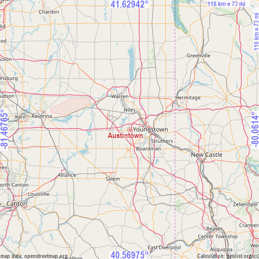
Austintown GPS coordinates[2]
41° 6' 6.192" North, 80° 45' 52.272" West
| Map corner | latitude | longitude |
|---|---|---|
| Upper-left | 41.62942°, | -81.46765° |
| Center: | 41.10172°, | -80.76452° |
| Lower-right: | 40.56975°, | -80.0614° |
| Map W x H: | 117.8×117.8 km | = 73.2×73.2mi |
| max Lat: | 71.29058° ⇑33.1% North |
| Austintown: | 41.10172° |
| min Lat: | ⇓66.9% South 19.06759° |
| min Long | Austintown | max Long |
| -171.73463° | -80.76452° | -66.98998° |
| W 70%⇐ | ⇒30% E |
Elevation
Elevation of Austintown is 345 m = 1132 ft, and this is 50.2 m = 165 ft above average elevation for this country.
| Max E: |
3189 m = 10463 ft | 20.9% |
| Austintown | 345 m 1132 ft | |
| Avg. | 294.8 m = 967 ft | |
Min E: |
-60 m = -197 ft | 79.1% |
See also: United States elevation on elevation.city.
Geographical zone
Austintown is located in North temperate zone (between Tropic of Cancer and the Arctic Circle). Distance of this Northern Tropic circle is 1964.2 km =1220.5 mi to South.| Distance of | km | miles | from Austintown |
|---|---|---|---|
| North Pole | 5437 | 3378.4 | to North |
| Arctic Circle | 2831.1 | 1759.2 | to North |
| Tropic Cancer | 1964.2 | 1220.5 | to South |
| Equator | 4570.1 | 2839.7 | to South |


Nearby cities:
15 places around Austintown: (largest is in red/bold)
• Boardman
12.1 km =7.5 mi,  135°
135°
• Bolindale
11.8 km =7.3 mi,  354°
354°
• Campbell
14.1 km =8.8 mi,  100°
100°
• Canfield
8.5 km =5.3 mi,  177°
177°
• Churchill
10.7 km =6.6 mi,  51°
51°
• Girard
7.8 km =4.8 mi,  42°
42°
• Hilltop
7.3 km =4.5 mi,  18°
18°
• Lordstown
10.5 km =6.5 mi,  312°
312°
• McDonald
7.7 km =4.8 mi,  26°
26°
• McKinley Heights
9.9 km =6.2 mi, 23°
• Mineral Ridge
4.3 km =2.7 mi,  355°
355°
• Niles
9 km =5.6 mi, 359°
• Poland
15.2 km =9.4 mi,  124°
124°
• Struthers
14.2 km =8.8 mi,  112°
112°
• Youngstown
9.6 km =6 mi,  91°
91°
Sources, notices
• [Note1] Compared only with cities in United States existing in our database
• [Src1] Map data: © OpenStreetMap contributors (CC-BY-SA)
• [Src2] Other city data from geonames.org with taken over terms of usage.
• [Src3] Geographical zone / Annual Mean Temperature by Robert A. Rohde @ Wikipedia
