Canton geodata
Canton (Ohio) is a seat of a second-order administrative division; located in United States in America/New_York (GMT-4) time zone. With population of 71,885 people, there are 574 cities with bigger population in this country. Compared to other cities in United States, 63.2% of cities are located further ↓South; 68.2% of cities are located further ←West and 77.2% of cities have lower elevation than Canton. Note1


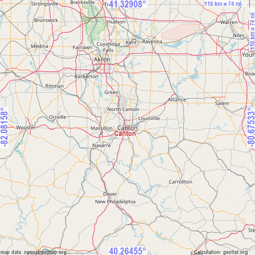
Canton GPS coordinates[2]
40° 47' 56.22" North, 81° 22' 42.42" West
| Map corner | latitude | longitude |
|---|---|---|
| Upper-left | 41.32908°, | -82.08158° |
| Center: | 40.79895°, | -81.37845° |
| Lower-right: | 40.26455°, | -80.67533° |
| Map W x H: | 118.4×118.4 km | = 73.6×73.6mi |
| max Lat: | 71.29058° ⇑36.8% North |
| Canton: | 40.79895° |
| min Lat: | ⇓63.2% South 19.06759° |
| min Long | Canton | max Long |
| -171.73463° | -81.37845° | -66.98998° |
| W 68.2%⇐ | ⇒31.8% E |
Elevation
Elevation of Canton is 329 m = 1079 ft, and this is 34.2 m = 112 ft above average elevation for this country.
| Max E: |
3189 m = 10463 ft | 22.8% |
| Canton | 329 m 1079 ft | |
| Avg. | 294.8 m = 967 ft | |
Min E: |
-60 m = -197 ft | 77.2% |
See also: Canton elevation on elevation.city.
Geographical zone
Canton is located in North temperate zone (between Tropic of Cancer and the Arctic Circle). Distance of this Northern Tropic circle is 1930.5 km =1199.6 mi to South.| Distance of | km | miles | from Canton |
|---|---|---|---|
| North Pole | 5470.6 | 3399.3 | to North |
| Arctic Circle | 2864.8 | 1780.1 | to North |
| Tropic Cancer | 1930.5 | 1199.6 | to South |
| Equator | 4536.4 | 2818.8 | to South |


Nearby cities:
15 places around Canton: (largest is in red/bold)
• Bolivar
17.7 km =11 mi,  200°
200°
• East Canton
8.2 km =5.1 mi,  99°
99°
• East Sparta
14.8 km =9.2 mi,  172°
172°
• Genoa
7.6 km =4.7 mi,  256°
256°
• Greensburg
16.5 km =10.3 mi,  333°
333°
• Greentown
14.4 km =8.9 mi,  351°
351°
• Louisville
10.9 km =6.8 mi,  66°
66°
• Magnolia
17.7 km =11 mi,  157°
157°
• Massillon
12 km =7.5 mi,  268°
268°
• Meyers Lake
3.5 km =2.2 mi,  295°
295°
• Navarre
14.7 km =9.1 mi,  235°
235°
• North Canton
8.8 km =5.5 mi, 346°
• Perry Heights
8 km =5 mi, 267°
• Richville
9.9 km =6.2 mi, 237°
• Waynesburg
17.8 km =11.1 mi,  145°
145°
Sources, notices
• [Note1] Compared only with cities in United States existing in our database
• [Src1] Map data: © OpenStreetMap contributors (CC-BY-SA)
• [Src2] Other city data from geonames.org with taken over terms of usage.
• [Src3] Geographical zone / Annual Mean Temperature by Robert A. Rohde @ Wikipedia
