Genoa geodata
Genoa (Ohio) is a populated place; located in United States in America/New_York (GMT-4) time zone. With population of 2,331 people, there are 11021 cities with bigger population in this country. Compared to other cities in United States, 62.9% of cities are located further ↓South; 67.8% of cities are located further ←West and 79.6% of cities have lower elevation than Genoa. Note1


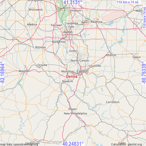
Genoa GPS coordinates[2]
40° 46' 58.224" North, 81° 27' 59.436" West
| Map corner | latitude | longitude |
|---|---|---|
| Upper-left | 41.3131°, | -82.16964° |
| Center: | 40.78284°, | -81.46651° |
| Lower-right: | 40.24831°, | -80.76339° |
| Map W x H: | 118.4×118.4 km | = 73.6×73.6mi |
| max Lat: | 71.29058° ⇑37.1% North |
| Genoa: | 40.78284° |
| min Lat: | ⇓62.9% South 19.06759° |
| min Long | Genoa | max Long |
| -171.73463° | -81.46651° | -66.98998° |
| W 67.8%⇐ | ⇒32.2% E |
Elevation
Elevation of Genoa is 349 m = 1145 ft, and this is 54.2 m = 178 ft above average elevation for this country.
| Max E: |
3189 m = 10463 ft | 20.4% |
| Genoa | 349 m 1145 ft | |
| Avg. | 294.8 m = 967 ft | |
Min E: |
-60 m = -197 ft | 79.6% |
See also: United States elevation on elevation.city.
Geographical zone
Genoa is located in North temperate zone (between Tropic of Cancer and the Arctic Circle). Distance of this Northern Tropic circle is 1928.7 km =1198.4 mi to South.| Distance of | km | miles | from Genoa |
|---|---|---|---|
| North Pole | 5472.4 | 3400.4 | to North |
| Arctic Circle | 2866.5 | 1781.2 | to North |
| Tropic Cancer | 1928.7 | 1198.4 | to South |
| Equator | 4534.6 | 2817.7 | to South |


Nearby cities:
15 places around Genoa: (largest is in red/bold)
• Beach City
17.4 km =10.8 mi,  213°
213°
• Bolivar
14.8 km =9.2 mi,  175°
175°
• Brewster
13.9 km =8.6 mi,  232°
232°
• Canal Fulton
16.2 km =10.1 mi,  317°
317°
• Canton
7.6 km =4.7 mi,  76°
76°
• East Canton
15.5 km =9.6 mi,  88°
88°
• East Sparta
15.9 km =9.9 mi,  143°
143°
• Greensburg
16.6 km =10.3 mi,  0°
0°
• Greentown
17 km =10.6 mi,  18°
18°
• Massillon
4.9 km =3 mi,  288°
288°
• Meyers Lake
5.4 km =3.4 mi,  51°
51°
• Navarre
8 km =5 mi,  215°
215°
• North Canton
11.7 km =7.3 mi,  27°
27°
• Perry Heights
1.5 km =0.9 mi,  337°
337°
• Richville
3.6 km =2.2 mi,  195°
195°
Sources, notices
• [Note1] Compared only with cities in United States existing in our database
• [Src1] Map data: © OpenStreetMap contributors (CC-BY-SA)
• [Src2] Other city data from geonames.org with taken over terms of usage.
• [Src3] Geographical zone / Annual Mean Temperature by Robert A. Rohde @ Wikipedia
