Dublin geodata
Dublin (Ohio) is a populated place; located in United States in America/New_York (GMT-4) time zone. With population of 45,098 people, there are 1057 cities with bigger population in this country. Compared to other cities in United States, 54.5% of cities are located further ↓South; 61.7% of cities are located further ←West and 63.1% of cities have lower elevation than Dublin. Note1


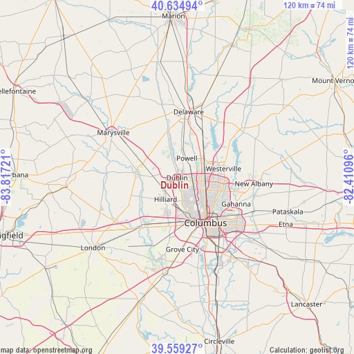
Dublin GPS coordinates[2]
40° 5' 57.228" North, 83° 6' 50.688" West
| Map corner | latitude | longitude |
|---|---|---|
| Upper-left | 40.63494°, | -83.81721° |
| Center: | 40.09923°, | -83.11408° |
| Lower-right: | 39.55927°, | -82.41096° |
| Map W x H: | 119.6×119.6 km | = 74.3×74.3mi |
| max Lat: | 71.29058° ⇑45.5% North |
| Dublin: | 40.09923° |
| min Lat: | ⇓54.5% South 19.06759° |
| min Long | Dublin | max Long |
| -171.73463° | -83.11408° | -66.98998° |
| W 61.7%⇐ | ⇒38.3% E |
Elevation
Elevation of Dublin is 253 m = 830 ft, and this is 41.8 m = 137 ft below average elevation for this country.
| Max E: |
3189 m = 10463 ft | 36.9% |
| Avg. | 294.8 m = 967 ft | |
| Dublin | 253 m = 830 ft | |
Min E: |
-60 m = -197 ft | 63.1% |
See also: Dublin elevation on elevation.city.
Geographical zone
Dublin is located in North temperate zone (between Tropic of Cancer and the Arctic Circle). Distance of this Northern Tropic circle is 1852.7 km =1151.2 mi to South.| Distance of | km | miles | from Dublin |
|---|---|---|---|
| North Pole | 5548.4 | 3447.6 | to North |
| Arctic Circle | 2942.6 | 1828.4 | to North |
| Tropic Cancer | 1852.7 | 1151.2 | to South |
| Equator | 4458.6 | 2770.4 | to South |


Nearby cities:
15 places around Dublin: (largest is in red/bold)
• Grandview Heights
14.7 km =9.1 mi,  154°
154°
• Hilliard
8.2 km =5.1 mi,  207°
207°
• Lewis Center
14.1 km =8.8 mi,  38°
38°
• Lincoln Village
16.1 km =10 mi,  185°
185°
• Marble Cliff
13.3 km =8.3 mi,  160°
160°
• Minerva Park
14.7 km =9.1 mi,  99°
99°
• New California
12.2 km =7.6 mi,  301°
301°
• Plain City
13.1 km =8.1 mi,  274°
274°
• Powell
7.3 km =4.5 mi,  26°
26°
• Riverlea
7.8 km =4.8 mi, 104°
• Shawnee Hills
6.7 km =4.2 mi,  345°
345°
• Upper Arlington
12.4 km =7.7 mi, 159°
• Valley View
15.3 km =9.5 mi,  166°
166°
• Westerville
16 km =9.9 mi,  79°
79°
• Worthington
8.2 km =5.1 mi,  94°
94°
Sources, notices
• [Note1] Compared only with cities in United States existing in our database
• [Src1] Map data: © OpenStreetMap contributors (CC-BY-SA)
• [Src2] Other city data from geonames.org with taken over terms of usage.
• [Src3] Geographical zone / Annual Mean Temperature by Robert A. Rohde @ Wikipedia
