Plain City geodata
Plain City (Ohio) is a populated place; located in United States in America/New_York (GMT-4) time zone. With population of 4,302 people, there are 7863 cities with bigger population in this country. Compared to other cities in United States, 54.6% of cities are located further ↓South; 61.2% of cities are located further ←West and 69.3% of cities have lower elevation than Plain City. Note1


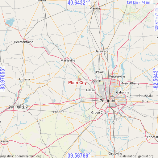
Plain City GPS coordinates[2]
40° 6' 27.216" North, 83° 16' 2.712" West
| Map corner | latitude | longitude |
|---|---|---|
| Upper-left | 40.64321°, | -83.97055° |
| Center: | 40.10756°, | -83.26742° |
| Lower-right: | 39.56766°, | -82.5643° |
| Map W x H: | 119.6×119.6 km | = 74.3×74.3mi |
| max Lat: | 71.29058° ⇑45.4% North |
| Plain City: | 40.10756° |
| min Lat: | ⇓54.6% South 19.06759° |
| min Long | Plain City | max Long |
| -171.73463° | -83.26742° | -66.98998° |
| W 61.2%⇐ | ⇒38.8% E |
Elevation
Elevation of Plain City is 282 m = 925 ft, and this is 12.8 m = 42 ft below average elevation for this country.
| Max E: |
3189 m = 10463 ft | 30.7% |
| Avg. | 294.8 m = 967 ft | |
| Plain City | 282 m = 925 ft | |
Min E: |
-60 m = -197 ft | 69.3% |
See also: United States elevation on elevation.city.
Geographical zone
Plain City is located in North temperate zone (between Tropic of Cancer and the Arctic Circle). Distance of this Northern Tropic circle is 1853.6 km =1151.8 mi to South.| Distance of | km | miles | from Plain City |
|---|---|---|---|
| North Pole | 5547.5 | 3447.1 | to North |
| Arctic Circle | 2941.6 | 1827.8 | to North |
| Tropic Cancer | 1853.6 | 1151.8 | to South |
| Equator | 4459.5 | 2771 | to South |


Nearby cities:
15 places around Plain City: (largest is in red/bold)
• Dublin
13.1 km =8.1 mi,  94°
94°
• Hilliard
12.4 km =7.7 mi,  131°
131°
• Lake Darby
17 km =10.6 mi,  168°
168°
• Lincoln Village
20.6 km =12.8 mi,  145°
145°
• Marble Cliff
22.1 km =13.7 mi, 127°
• Marysville
16.6 km =10.3 mi,  329°
329°
• Milford Center
16.3 km =10.1 mi,  298°
298°
• New California
6 km =3.7 mi,  25°
25°
• Ostrander
18.2 km =11.3 mi,  14°
14°
• Powell
17.3 km =10.7 mi,  71°
71°
• Riverlea
20.8 km =12.9 mi,  97°
97°
• Shawnee Hills
12.6 km =7.8 mi,  63°
63°
• Upper Arlington
21.5 km =13.4 mi, 125°
• West Jefferson
18.1 km =11.2 mi,  180°
180°
• Worthington
21.3 km =13.2 mi, 94°
Sources, notices
• [Note1] Compared only with cities in United States existing in our database
• [Src1] Map data: © OpenStreetMap contributors (CC-BY-SA)
• [Src2] Other city data from geonames.org with taken over terms of usage.
• [Src3] Geographical zone / Annual Mean Temperature by Robert A. Rohde @ Wikipedia
