Euclid geodata
Euclid (Ohio) is a populated place; located in United States in America/New_York (GMT-4) time zone. With population of 47,676 people, there are 1009 cities with bigger population in this country. Compared to other cities in United States, 71.8% of cities are located further ↓South; 67.5% of cities are located further ←West and 52.5% of cities have higher elevation than Euclid. Note1


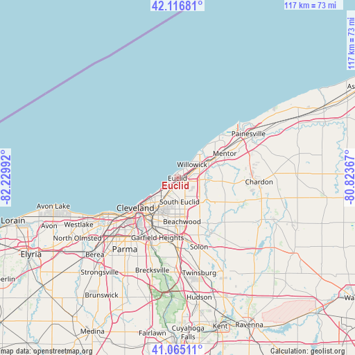
Euclid GPS coordinates[2]
41° 35' 35.16" North, 81° 31' 36.444" West
| Map corner | latitude | longitude |
|---|---|---|
| Upper-left | 42.11681°, | -82.22992° |
| Center: | 41.5931°, | -81.52679° |
| Lower-right: | 41.06511°, | -80.82367° |
| Map W x H: | 116.9×116.9 km | = 72.6×72.6mi |
| max Lat: | 71.29058° ⇑28.2% North |
| Euclid: | 41.5931° |
| min Lat: | ⇓71.8% South 19.06759° |
| min Long | Euclid | max Long |
| -171.73463° | -81.52679° | -66.98998° |
| W 67.5%⇐ | ⇒32.5% E |
Elevation
Elevation of Euclid is 189 m = 620 ft, and this is 105.8 m = 347 ft below average elevation for this country.
| Max E: |
3189 m = 10463 ft | 52.5% |
| Avg. | 294.8 m = 967 ft | |
| Euclid | 189 m = 620 ft | |
Min E: |
-60 m = -197 ft | 47.5% |
See also: Euclid elevation on elevation.city.
Geographical zone
Euclid is located in North temperate zone (between Tropic of Cancer and the Arctic Circle). Distance of this Northern Tropic circle is 2018.8 km =1254.4 mi to South.| Distance of | km | miles | from Euclid |
|---|---|---|---|
| North Pole | 5382.3 | 3344.4 | to North |
| Arctic Circle | 2776.5 | 1725.2 | to North |
| Tropic Cancer | 2018.8 | 1254.4 | to South |
| Equator | 4624.7 | 2873.7 | to South |


Nearby cities:
15 places around Euclid: (largest is in red/bold)
• Bratenahl
10 km =6.2 mi,  235°
235°
• Cleveland Heights
8.5 km =5.3 mi,  196°
196°
• Collinwood
5.2 km =3.2 mi,  222°
222°
• East Cleveland
8 km =5 mi,  213°
213°
• Eastlake
9.3 km =5.8 mi,  43°
43°
• Glenville
10 km =6.2 mi,  228°
228°
• Highland Heights
6.1 km =3.8 mi,  138°
138°
• Lyndhurst
8.7 km =5.4 mi,  158°
158°
• Mayfield
8.6 km =5.3 mi,  122°
122°
• Mayfield Heights
10 km =6.2 mi,  145°
145°
• Richmond Heights
4.7 km =2.9 mi, 162°
• South Euclid
7.8 km =4.8 mi,  174°
174°
• Wickliffe
6.2 km =3.9 mi,  77°
77°
• Willoughby Hills
9 km =5.6 mi,  86°
86°
• Willowick
6.6 km =4.1 mi,  47°
47°
Sources, notices
• [Note1] Compared only with cities in United States existing in our database
• [Src1] Map data: © OpenStreetMap contributors (CC-BY-SA)
• [Src2] Other city data from geonames.org with taken over terms of usage.
• [Src3] Geographical zone / Annual Mean Temperature by Robert A. Rohde @ Wikipedia
