Glenville geodata
Glenville (Ohio) is a populated place; located in United States in America/New_York (GMT-4) time zone. With population of 23,559 people, there are 2142 cities with bigger population in this country. Compared to other cities in United States, 71.2% of cities are located further ↓South; 67% of cities are located further ←West and 51.4% of cities have higher elevation than Glenville. Note1


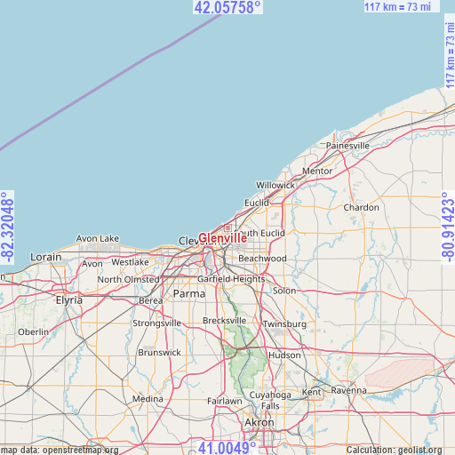
Glenville GPS coordinates[2]
41° 32' 0.168" North, 81° 37' 2.46" West
| Map corner | latitude | longitude |
|---|---|---|
| Upper-left | 42.05758°, | -82.32048° |
| Center: | 41.53338°, | -81.61735° |
| Lower-right: | 41.0049°, | -80.91423° |
| Map W x H: | 117×117 km | = 72.7×72.7mi |
| max Lat: | 71.29058° ⇑28.8% North |
| Glenville: | 41.53338° |
| min Lat: | ⇓71.2% South 19.06759° |
| min Long | Glenville | max Long |
| -171.73463° | -81.61735° | -66.98998° |
| W 67%⇐ | ⇒33% E |
Elevation
Elevation of Glenville is 193 m = 633 ft, and this is 101.8 m = 334 ft below average elevation for this country.
| Max E: |
3189 m = 10463 ft | 51.4% |
| Avg. | 294.8 m = 967 ft | |
| Glenville | 193 m = 633 ft | |
Min E: |
-60 m = -197 ft | 48.6% |
See also: United States elevation on elevation.city.
Geographical zone
Glenville is located in North temperate zone (between Tropic of Cancer and the Arctic Circle). Distance of this Northern Tropic circle is 2012.2 km =1250.3 mi to South.| Distance of | km | miles | from Glenville |
|---|---|---|---|
| North Pole | 5389 | 3348.6 | to North |
| Arctic Circle | 2783.1 | 1729.3 | to North |
| Tropic Cancer | 2012.2 | 1250.3 | to South |
| Equator | 4618.1 | 2869.6 | to South |


Nearby cities:
15 places around Glenville: (largest is in red/bold)
• Bratenahl
1.3 km =0.8 mi,  324°
324°
• Clark-Fulton
10.9 km =6.8 mi,  224°
224°
• Cleveland
7.5 km =4.7 mi,  239°
239°
• Cleveland Heights
5.3 km =3.3 mi,  106°
106°
• Collinwood
4.9 km =3 mi,  55°
55°
• East Cleveland
3.2 km =2 mi,  90°
90°
• Euclid
10 km =6.2 mi,  48°
48°
• Hough
2.9 km =1.8 mi,  213°
213°
• Lyndhurst
10.8 km =6.7 mi,  97°
97°
• Newburgh Heights
10 km =6.2 mi,  202°
202°
• Ohio City
9.5 km =5.9 mi, 235°
• Richmond Heights
9.2 km =5.7 mi,  76°
76°
• Shaker Heights
9.4 km =5.8 mi,  134°
134°
• South Euclid
8.3 km =5.2 mi, 97°
• University Heights
7.7 km =4.8 mi,  120°
120°
Sources, notices
• [Note1] Compared only with cities in United States existing in our database
• [Src1] Map data: © OpenStreetMap contributors (CC-BY-SA)
• [Src2] Other city data from geonames.org with taken over terms of usage.
• [Src3] Geographical zone / Annual Mean Temperature by Robert A. Rohde @ Wikipedia
