Glandorf geodata
Glandorf (Ohio) is a populated place; located in United States in America/New_York (GMT-4) time zone. With population of 1,006 people, there are 16243 cities with bigger population in this country. Compared to other cities in United States, 66.2% of cities are located further ↓South; 59% of cities are located further ←West and 55.8% of cities have lower elevation than Glandorf. Note1


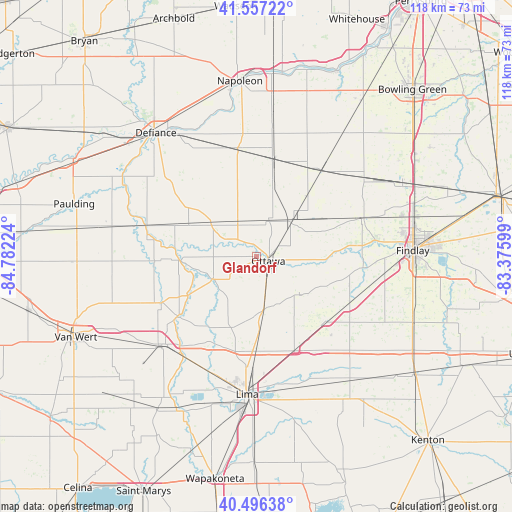
Glandorf GPS coordinates[2]
41° 1' 44.184" North, 84° 4' 44.796" West
| Map corner | latitude | longitude |
|---|---|---|
| Upper-left | 41.55722°, | -84.78224° |
| Center: | 41.02894°, | -84.07911° |
| Lower-right: | 40.49638°, | -83.37599° |
| Map W x H: | 118×118 km | = 73.3×73.3mi |
| max Lat: | 71.29058° ⇑33.8% North |
| Glandorf: | 41.02894° |
| min Lat: | ⇓66.2% South 19.06759° |
| min Long | Glandorf | max Long |
| -171.73463° | -84.07911° | -66.98998° |
| W 59%⇐ | ⇒41% E |
Elevation
Elevation of Glandorf is 222 m = 728 ft, and this is 72.8 m = 239 ft below average elevation for this country.
| Max E: |
3189 m = 10463 ft | 44.2% |
| Avg. | 294.8 m = 967 ft | |
| Glandorf | 222 m = 728 ft | |
Min E: |
-60 m = -197 ft | 55.8% |
See also: United States elevation on elevation.city.
Geographical zone
Glandorf is located in North temperate zone (between Tropic of Cancer and the Arctic Circle). Distance of this Northern Tropic circle is 1956.1 km =1215.5 mi to South.| Distance of | km | miles | from Glandorf |
|---|---|---|---|
| North Pole | 5445.1 | 3383.4 | to North |
| Arctic Circle | 2839.2 | 1764.2 | to North |
| Tropic Cancer | 1956.1 | 1215.5 | to South |
| Equator | 4562 | 2834.7 | to South |


Nearby cities:
15 places around Glandorf: (largest is in red/bold)
• Bluffton
21.8 km =13.5 mi,  132°
132°
• Cairo
21.9 km =13.6 mi,  181°
181°
• Columbus Grove
12.3 km =7.6 mi,  171°
171°
• Continental
17.6 km =10.9 mi,  296°
296°
• Deshler
24.9 km =15.5 mi,  37°
37°
• Hamler
22.6 km =14 mi,  9°
9°
• Holgate
24.9 km =15.5 mi,  349°
349°
• Kalida
11.3 km =7 mi,  243°
243°
• Leipsic
11.1 km =6.9 mi,  45°
45°
• McComb
25.6 km =15.9 mi,  69°
69°
• Oakwood
26.3 km =16.3 mi,  286°
286°
• Ottawa
2.9 km =1.8 mi,  111°
111°
• Ottoville
24.3 km =15.1 mi, 243°
• Pandora
13.4 km =8.3 mi, 132°
• Rawson
26 km =16.2 mi, 107°
Sources, notices
• [Note1] Compared only with cities in United States existing in our database
• [Src1] Map data: © OpenStreetMap contributors (CC-BY-SA)
• [Src2] Other city data from geonames.org with taken over terms of usage.
• [Src3] Geographical zone / Annual Mean Temperature by Robert A. Rohde @ Wikipedia
