McComb geodata
McComb (Ohio) is a populated place; located in United States in America/New_York (GMT-4) time zone. With population of 1,644 people, there are 13109 cities with bigger population in this country. Compared to other cities in United States, 66.9% of cities are located further ↓South; 59.8% of cities are located further ←West and 59.1% of cities have lower elevation than McComb. Note1


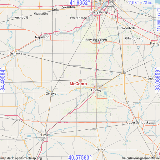
McComb GPS coordinates[2]
41° 6' 27.18" North, 83° 47' 33.756" West
| Map corner | latitude | longitude |
|---|---|---|
| Upper-left | 41.6352°, | -84.49584° |
| Center: | 41.10755°, | -83.79271° |
| Lower-right: | 40.57563°, | -83.08959° |
| Map W x H: | 117.8×117.8 km | = 73.2×73.2mi |
| max Lat: | 71.29058° ⇑33.1% North |
| McComb: | 41.10755° |
| min Lat: | ⇓66.9% South 19.06759° |
| min Long | McComb | max Long |
| -171.73463° | -83.79271° | -66.98998° |
| W 59.8%⇐ | ⇒40.2% E |
Elevation
Elevation of McComb is 236 m = 774 ft, and this is 58.8 m = 193 ft below average elevation for this country.
| Max E: |
3189 m = 10463 ft | 40.9% |
| Avg. | 294.8 m = 967 ft | |
| McComb | 236 m = 774 ft | |
Min E: |
-60 m = -197 ft | 59.1% |
See also: United States elevation on elevation.city.
Geographical zone
McComb is located in North temperate zone (between Tropic of Cancer and the Arctic Circle). Distance of this Northern Tropic circle is 1964.8 km =1220.9 mi to South.| Distance of | km | miles | from McComb |
|---|---|---|---|
| North Pole | 5436.3 | 3378 | to North |
| Arctic Circle | 2830.4 | 1758.7 | to North |
| Tropic Cancer | 1964.8 | 1220.9 | to South |
| Equator | 4570.7 | 2840.1 | to South |


Nearby cities:
15 places around McComb: (largest is in red/bold)
• Arcadia
23.1 km =14.4 mi,  89°
89°
• Arlington
26.6 km =16.5 mi,  153°
153°
• Bloomdale
21.1 km =13.1 mi,  69°
69°
• Bluffton
24.9 km =15.5 mi,  198°
198°
• Cygnet
19.3 km =12 mi,  40°
40°
• Deshler
14.2 km =8.8 mi,  321°
321°
• Findlay
13.9 km =8.6 mi,  120°
120°
• Glandorf
25.6 km =15.9 mi,  249°
249°
• Hamler
24.3 km =15.1 mi,  303°
303°
• Leipsic
16.1 km =10 mi,  266°
266°
• North Baltimore
12.7 km =7.9 mi,  48°
48°
• Ottawa
23.5 km =14.6 mi, 245°
• Pandora
22.7 km =14.1 mi,  218°
218°
• Rawson
16.5 km =10.3 mi,  177°
177°
• Weston
26.4 km =16.4 mi,  359°
359°
Sources, notices
• [Note1] Compared only with cities in United States existing in our database
• [Src1] Map data: © OpenStreetMap contributors (CC-BY-SA)
• [Src2] Other city data from geonames.org with taken over terms of usage.
• [Src3] Geographical zone / Annual Mean Temperature by Robert A. Rohde @ Wikipedia
