Hanover geodata
Hanover (Ohio) is a populated place; located in United States in America/New_York (GMT-4) time zone. With population of 1,131 people, there are 15501 cities with bigger population in this country. Compared to other cities in United States, 54.3% of cities are located further ↓South; 64.7% of cities are located further ←West and 62.8% of cities have lower elevation than Hanover. Note1


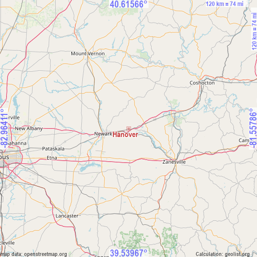
Hanover GPS coordinates[2]
40° 4' 47.244" North, 82° 15' 39.528" West
| Map corner | latitude | longitude |
|---|---|---|
| Upper-left | 40.61566°, | -82.96411° |
| Center: | 40.07979°, | -82.26098° |
| Lower-right: | 39.53967°, | -81.55786° |
| Map W x H: | 119.6×119.6 km | = 74.3×74.3mi |
| max Lat: | 71.29058° ⇑45.7% North |
| Hanover: | 40.07979° |
| min Lat: | ⇓54.3% South 19.06759° |
| min Long | Hanover | max Long |
| -171.73463° | -82.26098° | -66.98998° |
| W 64.7%⇐ | ⇒35.3% E |
Elevation
Elevation of Hanover is 252 m = 827 ft, and this is 42.8 m = 140 ft below average elevation for this country.
| Max E: |
3189 m = 10463 ft | 37.2% |
| Avg. | 294.8 m = 967 ft | |
| Hanover | 252 m = 827 ft | |
Min E: |
-60 m = -197 ft | 62.8% |
See also: United States elevation on elevation.city.
Geographical zone
Hanover is located in North temperate zone (between Tropic of Cancer and the Arctic Circle). Distance of this Northern Tropic circle is 1850.5 km =1149.8 mi to South.| Distance of | km | miles | from Hanover |
|---|---|---|---|
| North Pole | 5550.6 | 3449 | to North |
| Arctic Circle | 2944.7 | 1829.8 | to North |
| Tropic Cancer | 1850.5 | 1149.8 | to South |
| Equator | 4456.5 | 2769.1 | to South |


Nearby cities:
15 places around Hanover: (largest is in red/bold)
• Amsterdam
16.9 km =10.5 mi,  216°
216°
• Buckeye Lake
24.3 km =15.1 mi,  227°
227°
• Dresden
21.8 km =13.5 mi,  77°
77°
• Frazeysburg
12.8 km =8 mi,  70°
70°
• Granville
22 km =13.7 mi,  266°
266°
• Granville South
24.1 km =15 mi,  262°
262°
• Harbor Hills
21.7 km =13.5 mi, 223°
• Heath
16.9 km =10.5 mi,  247°
247°
• Hebron
23.6 km =14.7 mi,  236°
236°
• Marne
4.2 km =2.6 mi, 256°
• Newark
12.2 km =7.6 mi, 258°
• North Zanesville
24.6 km =15.3 mi,  117°
117°
• Thornport
22.5 km =14 mi,  214°
214°
• Thornville
24.5 km =15.2 mi, 213°
• Utica
23.6 km =14.7 mi,  316°
316°
Sources, notices
• [Note1] Compared only with cities in United States existing in our database
• [Src1] Map data: © OpenStreetMap contributors (CC-BY-SA)
• [Src2] Other city data from geonames.org with taken over terms of usage.
• [Src3] Geographical zone / Annual Mean Temperature by Robert A. Rohde @ Wikipedia
