Newark geodata
Newark (Ohio) is a seat of a second-order administrative division; located in United States in America/New_York (GMT-4) time zone. With population of 47,986 people, there are 1000 cities with bigger population in this country. Compared to other cities in United States, 54.1% of cities are located further ↓South; 64.3% of cities are located further ←West and 64.5% of cities have lower elevation than Newark. Note1


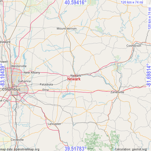
Newark GPS coordinates[2]
40° 3' 29.232" North, 82° 24' 4.536" West
| Map corner | latitude | longitude |
|---|---|---|
| Upper-left | 40.59416°, | -83.10439° |
| Center: | 40.05812°, | -82.40126° |
| Lower-right: | 39.51783°, | -81.69814° |
| Map W x H: | 119.7×119.7 km | = 74.4×74.4mi |
| max Lat: | 71.29058° ⇑45.9% North |
| Newark: | 40.05812° |
| min Lat: | ⇓54.1% South 19.06759° |
| min Long | Newark | max Long |
| -171.73463° | -82.40126° | -66.98998° |
| W 64.3%⇐ | ⇒35.7% E |
Elevation
Elevation of Newark is 260 m = 853 ft, and this is 34.8 m = 114 ft below average elevation for this country.
| Max E: |
3189 m = 10463 ft | 35.5% |
| Avg. | 294.8 m = 967 ft | |
| Newark | 260 m = 853 ft | |
Min E: |
-60 m = -197 ft | 64.5% |
See also: Newark elevation on elevation.city.
Geographical zone
Newark is located in North temperate zone (between Tropic of Cancer and the Arctic Circle). Distance of this Northern Tropic circle is 1848.1 km =1148.4 mi to South.| Distance of | km | miles | from Newark |
|---|---|---|---|
| North Pole | 5553 | 3450.5 | to North |
| Arctic Circle | 2947.1 | 1831.2 | to North |
| Tropic Cancer | 1848.1 | 1148.4 | to South |
| Equator | 4454 | 2767.6 | to South |


Nearby cities:
15 places around Newark: (largest is in red/bold)
• Alexandria
18.3 km =11.4 mi,  280°
280°
• Amsterdam
11.4 km =7.1 mi,  170°
170°
• Buckeye Lake
15.1 km =9.4 mi,  203°
203°
• Fairfield Beach
17 km =10.6 mi, 201°
• Granville
10.1 km =6.3 mi, 276°
• Granville South
12 km =7.5 mi,  266°
266°
• Hanover
12.2 km =7.6 mi,  78°
78°
• Harbor Hills
13.8 km =8.6 mi,  192°
192°
• Heath
5.4 km =3.4 mi,  223°
223°
• Hebron
13.2 km =8.2 mi, 215°
• Kirkersville
19.9 km =12.4 mi,  236°
236°
• Marne
8 km =5 mi, 79°
• Thornport
16.1 km =10 mi,  182°
182°
• Thornville
18 km =11.2 mi, 185°
• Utica
20 km =12.4 mi,  347°
347°
Sources, notices
• [Note1] Compared only with cities in United States existing in our database
• [Src1] Map data: © OpenStreetMap contributors (CC-BY-SA)
• [Src2] Other city data from geonames.org with taken over terms of usage.
• [Src3] Geographical zone / Annual Mean Temperature by Robert A. Rohde @ Wikipedia
