New Albany geodata
New Albany (Ohio) is a populated place; located in United States in America/New_York (GMT-4) time zone. With population of 9,879 people, there are 4500 cities with bigger population in this country. Compared to other cities in United States, 54.3% of cities are located further ↓South; 62.6% of cities are located further ←West and 74.7% of cities have lower elevation than New Albany. Note1


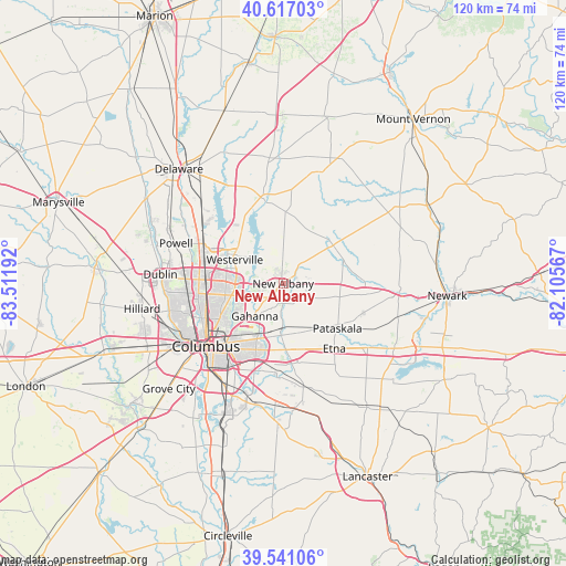
New Albany GPS coordinates[2]
40° 4' 52.212" North, 82° 48' 31.644" West
| Map corner | latitude | longitude |
|---|---|---|
| Upper-left | 40.61703°, | -83.51192° |
| Center: | 40.08117°, | -82.80879° |
| Lower-right: | 39.54106°, | -82.10567° |
| Map W x H: | 119.6×119.6 km | = 74.3×74.3mi |
| max Lat: | 71.29058° ⇑45.7% North |
| New Albany: | 40.08117° |
| min Lat: | ⇓54.3% South 19.06759° |
| min Long | New Albany | max Long |
| -171.73463° | -82.80879° | -66.98998° |
| W 62.6%⇐ | ⇒37.4% E |
Elevation
Elevation of New Albany is 311 m = 1020 ft, and this is 16.2 m = 53 ft above average elevation for this country.
| Max E: |
3189 m = 10463 ft | 25.3% |
| New Albany | 311 m 1020 ft | |
| Avg. | 294.8 m = 967 ft | |
Min E: |
-60 m = -197 ft | 74.7% |
See also: United States elevation on elevation.city.
Geographical zone
New Albany is located in North temperate zone (between Tropic of Cancer and the Arctic Circle). Distance of this Northern Tropic circle is 1850.7 km =1150 mi to South.| Distance of | km | miles | from New Albany |
|---|---|---|---|
| North Pole | 5550.5 | 3448.9 | to North |
| Arctic Circle | 2944.6 | 1829.7 | to North |
| Tropic Cancer | 1850.7 | 1150 | to South |
| Equator | 4456.6 | 2769.2 | to South |


Nearby cities:
15 places around New Albany: (largest is in red/bold)
• Alexandria
16.7 km =10.4 mi,  87°
87°
• Beechwood Trails
14.9 km =9.3 mi,  115°
115°
• Bexley
16.6 km =10.3 mi,  221°
221°
• Etna
17.5 km =10.9 mi,  141°
141°
• Gahanna
9.1 km =5.7 mi, 221°
• Galena
16.1 km =10 mi,  337°
337°
• Huber Ridge
9.2 km =5.7 mi,  275°
275°
• Johnstown
13.2 km =8.2 mi,  52°
52°
• Minerva Park
11.5 km =7.1 mi,  267°
267°
• Pataskala
14.9 km =9.3 mi,  129°
129°
• Reynoldsburg
14.1 km =8.8 mi,  181°
181°
• Riverlea
18.4 km =11.4 mi, 270°
• Westerville
11.4 km =7.1 mi,  296°
296°
• Whitehall
14.3 km =8.9 mi,  207°
207°
• Worthington
17.8 km =11.1 mi, 274°
Sources, notices
• [Note1] Compared only with cities in United States existing in our database
• [Src1] Map data: © OpenStreetMap contributors (CC-BY-SA)
• [Src2] Other city data from geonames.org with taken over terms of usage.
• [Src3] Geographical zone / Annual Mean Temperature by Robert A. Rohde @ Wikipedia
