Norwalk geodata
Norwalk (Ohio) is a seat of a second-order administrative division; located in United States in America/New_York (GMT-4) time zone. With population of 16,827 people, there are 2916 cities with bigger population in this country. Compared to other cities in United States, 68.2% of cities are located further ↓South; 63.2% of cities are located further ←West and 56.1% of cities have lower elevation than Norwalk. Note1


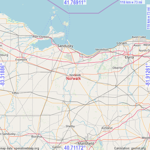
Norwalk GPS coordinates[2]
41° 14' 33.18" North, 82° 36' 56.628" West
| Map corner | latitude | longitude |
|---|---|---|
| Upper-left | 41.76911°, | -83.31886° |
| Center: | 41.24255°, | -82.61573° |
| Lower-right: | 40.71172°, | -81.91261° |
| Map W x H: | 117.6×117.6 km | = 73.1×73.1mi |
| max Lat: | 71.29058° ⇑31.8% North |
| Norwalk: | 41.24255° |
| min Lat: | ⇓68.2% South 19.06759° |
| min Long | Norwalk | max Long |
| -171.73463° | -82.61573° | -66.98998° |
| W 63.2%⇐ | ⇒36.8% E |
Elevation
Elevation of Norwalk is 223 m = 732 ft, and this is 71.8 m = 236 ft below average elevation for this country.
| Max E: |
3189 m = 10463 ft | 43.9% |
| Avg. | 294.8 m = 967 ft | |
| Norwalk | 223 m = 732 ft | |
Min E: |
-60 m = -197 ft | 56.1% |
See also: United States elevation on elevation.city.
Geographical zone
Norwalk is located in North temperate zone (between Tropic of Cancer and the Arctic Circle). Distance of this Northern Tropic circle is 1979.8 km =1230.2 mi to South.| Distance of | km | miles | from Norwalk |
|---|---|---|---|
| North Pole | 5421.3 | 3368.6 | to North |
| Arctic Circle | 2815.4 | 1749.4 | to North |
| Tropic Cancer | 1979.8 | 1230.2 | to South |
| Equator | 4585.7 | 2849.4 | to South |


Nearby cities:
15 places around Norwalk: (largest is in red/bold)
• Bellevue
19.2 km =11.9 mi,  280°
280°
• Berlin Heights
13.8 km =8.6 mi,  48°
48°
• Camden
25.9 km =16.1 mi,  91°
91°
• Castalia
23.8 km =14.8 mi,  317°
317°
• Collins
10.6 km =6.6 mi,  80°
80°
• Greenwich
25.1 km =15.6 mi,  160°
160°
• Huron
17.7 km =11 mi,  16°
16°
• Milan
6.2 km =3.9 mi,  7°
7°
• Monroeville
6.7 km =4.2 mi,  271°
271°
• Mount Carmel
27 km =16.8 mi, 276°
• New London
25.2 km =15.7 mi,  134°
134°
• North Fairfield
15.4 km =9.6 mi,  178°
178°
• Sandusky
24.2 km =15 mi,  341°
341°
• Wakeman
18.1 km =11.2 mi, 85°
• Willard
23 km =14.3 mi,  203°
203°
Sources, notices
• [Note1] Compared only with cities in United States existing in our database
• [Src1] Map data: © OpenStreetMap contributors (CC-BY-SA)
• [Src2] Other city data from geonames.org with taken over terms of usage.
• [Src3] Geographical zone / Annual Mean Temperature by Robert A. Rohde @ Wikipedia
