Monroeville geodata
Monroeville (Ohio) is a populated place; located in United States in America/New_York (GMT-4) time zone. With population of 1,370 people, there are 14261 cities with bigger population in this country. Compared to other cities in United States, 68.2% of cities are located further ↓South; 63% of cities are located further ←West and 54.4% of cities have lower elevation than Monroeville. Note1


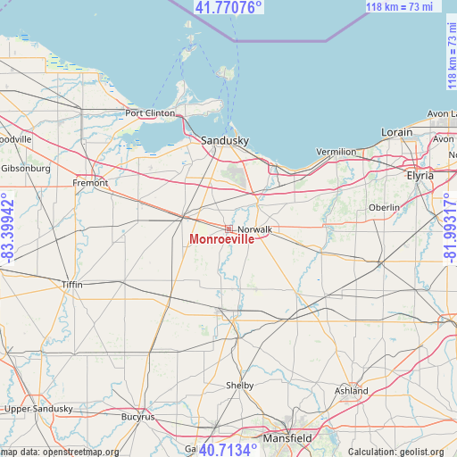
Monroeville GPS coordinates[2]
41° 14' 39.192" North, 82° 41' 46.644" West
| Map corner | latitude | longitude |
|---|---|---|
| Upper-left | 41.77076°, | -83.39942° |
| Center: | 41.24422°, | -82.69629° |
| Lower-right: | 40.7134°, | -81.99317° |
| Map W x H: | 117.6×117.6 km | = 73.1×73.1mi |
| max Lat: | 71.29058° ⇑31.8% North |
| Monroeville: | 41.24422° |
| min Lat: | ⇓68.2% South 19.06759° |
| min Long | Monroeville | max Long |
| -171.73463° | -82.69629° | -66.98998° |
| W 63%⇐ | ⇒37% E |
Elevation
Elevation of Monroeville is 216 m = 709 ft, and this is 78.8 m = 259 ft below average elevation for this country.
| Max E: |
3189 m = 10463 ft | 45.6% |
| Avg. | 294.8 m = 967 ft | |
| Monroeville | 216 m = 709 ft | |
Min E: |
-60 m = -197 ft | 54.4% |
See also: United States elevation on elevation.city.
Geographical zone
Monroeville is located in North temperate zone (between Tropic of Cancer and the Arctic Circle). Distance of this Northern Tropic circle is 1980 km =1230.3 mi to South.| Distance of | km | miles | from Monroeville |
|---|---|---|---|
| North Pole | 5421.1 | 3368.5 | to North |
| Arctic Circle | 2815.2 | 1749.3 | to North |
| Tropic Cancer | 1980 | 1230.3 | to South |
| Equator | 4585.9 | 2849.5 | to South |


Nearby cities:
15 places around Monroeville: (largest is in red/bold)
• Attica
25.6 km =15.9 mi,  218°
218°
• Bay View
27.2 km =16.9 mi,  336°
336°
• Bellevue
12.6 km =7.8 mi,  285°
285°
• Berlin Heights
19.2 km =11.9 mi,  62°
62°
• Castalia
19.7 km =12.2 mi,  331°
331°
• Clyde
24.2 km =15 mi, 285°
• Collins
17.2 km =10.7 mi,  84°
84°
• Huron
20.5 km =12.7 mi,  35°
35°
• Milan
9.6 km =6 mi,  52°
52°
• Mount Carmel
20.3 km =12.6 mi,  278°
278°
• North Fairfield
17.1 km =10.6 mi,  155°
155°
• Norwalk
6.7 km =4.2 mi,  91°
91°
• Sandusky
22.8 km =14.2 mi,  357°
357°
• Wakeman
24.8 km =15.4 mi, 87°
• Willard
21.4 km =13.3 mi,  186°
186°
Sources, notices
• [Note1] Compared only with cities in United States existing in our database
• [Src1] Map data: © OpenStreetMap contributors (CC-BY-SA)
• [Src2] Other city data from geonames.org with taken over terms of usage.
• [Src3] Geographical zone / Annual Mean Temperature by Robert A. Rohde @ Wikipedia
