Pemberville geodata
Pemberville (Ohio) is a populated place; located in United States in America/New_York (GMT-4) time zone. With population of 1,423 people, there are 14000 cities with bigger population in this country. Compared to other cities in United States, 69.9% of cities are located further ↓South; 60.7% of cities are located further ←West and 50.5% of cities have lower elevation than Pemberville. Note1


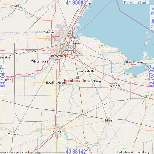
Pemberville GPS coordinates[2]
41° 24' 39.204" North, 83° 27' 39.744" West
| Map corner | latitude | longitude |
|---|---|---|
| Upper-left | 41.93608°, | -84.16417° |
| Center: | 41.41089°, | -83.46104° |
| Lower-right: | 40.88142°, | -82.75792° |
| Map W x H: | 117.3×117.3 km | = 72.9×72.9mi |
| max Lat: | 71.29058° ⇑30.1% North |
| Pemberville: | 41.41089° |
| min Lat: | ⇓69.9% South 19.06759° |
| min Long | Pemberville | max Long |
| -171.73463° | -83.46104° | -66.98998° |
| W 60.7%⇐ | ⇒39.3% E |
Elevation
Elevation of Pemberville is 200 m = 656 ft, and this is 94.8 m = 311 ft below average elevation for this country.
| Max E: |
3189 m = 10463 ft | 49.5% |
| Avg. | 294.8 m = 967 ft | |
| Pemberville | 200 m = 656 ft | |
Min E: |
-60 m = -197 ft | 50.5% |
See also: United States elevation on elevation.city.
Geographical zone
Pemberville is located in North temperate zone (between Tropic of Cancer and the Arctic Circle). Distance of this Northern Tropic circle is 1998.5 km =1241.8 mi to South.| Distance of | km | miles | from Pemberville |
|---|---|---|---|
| North Pole | 5402.6 | 3357 | to North |
| Arctic Circle | 2796.7 | 1737.8 | to North |
| Tropic Cancer | 1998.5 | 1241.8 | to South |
| Equator | 4604.5 | 2861.1 | to South |


Nearby cities:
15 places around Pemberville: (largest is in red/bold)
• Bowling Green
16.4 km =10.2 mi,  255°
255°
• Bradner
9.8 km =6.1 mi,  168°
168°
• Elmore
15.6 km =9.7 mi,  62°
62°
• Genoa
14.6 km =9.1 mi,  35°
35°
• Gibsonburg
12.1 km =7.5 mi,  104°
104°
• Haskins
21.3 km =13.2 mi,  286°
286°
• Luckey
4.9 km =3 mi,  333°
333°
• Maumee
23.3 km =14.5 mi,  316°
316°
• Millbury
17.5 km =10.9 mi,  9°
9°
• Northwood
21.8 km =13.5 mi,  358°
358°
• Perrysburg
21.3 km =13.2 mi, 319°
• Risingsun
16 km =9.9 mi, 169°
• Walbridge
19.9 km =12.4 mi,  352°
352°
• Wayne
12.2 km =7.6 mi,  184°
184°
• Woodville
9.1 km =5.7 mi, 60°
Sources, notices
• [Note1] Compared only with cities in United States existing in our database
• [Src1] Map data: © OpenStreetMap contributors (CC-BY-SA)
• [Src2] Other city data from geonames.org with taken over terms of usage.
• [Src3] Geographical zone / Annual Mean Temperature by Robert A. Rohde @ Wikipedia
