Woodville geodata
Woodville (Ohio) is a populated place; located in United States in America/New_York (GMT-4) time zone. With population of 2,083 people, there are 11682 cities with bigger population in this country. Compared to other cities in United States, 70.3% of cities are located further ↓South; 61% of cities are located further ←West and 51.1% of cities have higher elevation than Woodville. Note1


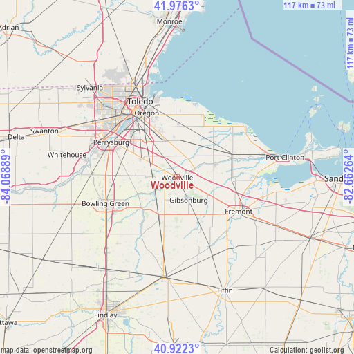
Woodville GPS coordinates[2]
41° 27' 5.184" North, 83° 21' 56.736" West
| Map corner | latitude | longitude |
|---|---|---|
| Upper-left | 41.9763°, | -84.06889° |
| Center: | 41.45144°, | -83.36576° |
| Lower-right: | 40.9223°, | -82.66264° |
| Map W x H: | 117.2×117.2 km | = 72.8×72.8mi |
| max Lat: | 71.29058° ⇑29.7% North |
| Woodville: | 41.45144° |
| min Lat: | ⇓70.3% South 19.06759° |
| min Long | Woodville | max Long |
| -171.73463° | -83.36576° | -66.98998° |
| W 61%⇐ | ⇒39% E |
Elevation
Elevation of Woodville is 194 m = 636 ft, and this is 100.8 m = 331 ft below average elevation for this country.
| Max E: |
3189 m = 10463 ft | 51.1% |
| Avg. | 294.8 m = 967 ft | |
| Woodville | 194 m = 636 ft | |
Min E: |
-60 m = -197 ft | 48.9% |
See also: United States elevation on elevation.city.
Geographical zone
Woodville is located in North temperate zone (between Tropic of Cancer and the Arctic Circle). Distance of this Northern Tropic circle is 2003 km =1244.6 mi to South.| Distance of | km | miles | from Woodville |
|---|---|---|---|
| North Pole | 5398.1 | 3354.2 | to North |
| Arctic Circle | 2792.2 | 1735 | to North |
| Tropic Cancer | 2003 | 1244.6 | to South |
| Equator | 4609 | 2863.9 | to South |


Nearby cities:
15 places around Woodville: (largest is in red/bold)
• Bradner
15.4 km =9.6 mi,  203°
203°
• Curtice
18.6 km =11.6 mi,  359°
359°
• Elmore
6.4 km =4 mi,  64°
64°
• Fremont
23.2 km =14.4 mi,  118°
118°
• Genoa
7.4 km =4.6 mi,  4°
4°
• Gibsonburg
8.3 km =5.2 mi,  153°
153°
• Luckey
10.1 km =6.3 mi,  269°
269°
• Millbury
13.7 km =8.5 mi,  338°
338°
• Northwood
19.3 km =12 mi,  333°
333°
• Oak Harbor
19.3 km =12 mi,  71°
71°
• Pemberville
9.1 km =5.7 mi,  240°
240°
• Risingsun
20.8 km =12.9 mi,  193°
193°
• Stony Prairie
20.8 km =12.9 mi, 122°
• Walbridge
18.5 km =11.5 mi, 325°
• Wayne
18.9 km =11.7 mi,  208°
208°
Sources, notices
• [Note1] Compared only with cities in United States existing in our database
• [Src1] Map data: © OpenStreetMap contributors (CC-BY-SA)
• [Src2] Other city data from geonames.org with taken over terms of usage.
• [Src3] Geographical zone / Annual Mean Temperature by Robert A. Rohde @ Wikipedia
