Swanton geodata
Swanton (Ohio) is a populated place; located in United States in America/New_York (GMT-4) time zone. With population of 3,886 people, there are 8348 cities with bigger population in this country. Compared to other cities in United States, 71.7% of cities are located further ↓South; 59.6% of cities are located further ←West and 52.5% of cities have lower elevation than Swanton. Note1


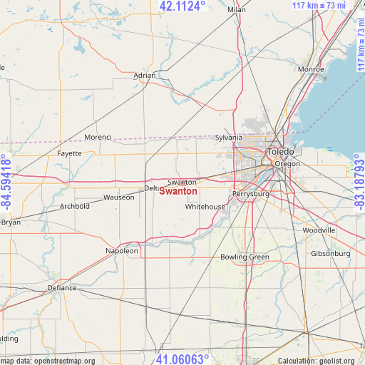
Swanton GPS coordinates[2]
41° 35' 19.176" North, 83° 53' 27.78" West
| Map corner | latitude | longitude |
|---|---|---|
| Upper-left | 42.1124°, | -84.59418° |
| Center: | 41.58866°, | -83.89105° |
| Lower-right: | 41.06063°, | -83.18793° |
| Map W x H: | 116.9×116.9 km | = 72.6×72.6mi |
| max Lat: | 71.29058° ⇑28.3% North |
| Swanton: | 41.58866° |
| min Lat: | ⇓71.7% South 19.06759° |
| min Long | Swanton | max Long |
| -171.73463° | -83.89105° | -66.98998° |
| W 59.6%⇐ | ⇒40.4% E |
Elevation
Elevation of Swanton is 208 m = 682 ft, and this is 86.8 m = 285 ft below average elevation for this country.
| Max E: |
3189 m = 10463 ft | 47.5% |
| Avg. | 294.8 m = 967 ft | |
| Swanton | 208 m = 682 ft | |
Min E: |
-60 m = -197 ft | 52.5% |
See also: United States elevation on elevation.city.
Geographical zone
Swanton is located in North temperate zone (between Tropic of Cancer and the Arctic Circle). Distance of this Northern Tropic circle is 2018.3 km =1254.1 mi to South.| Distance of | km | miles | from Swanton |
|---|---|---|---|
| North Pole | 5382.8 | 3344.7 | to North |
| Arctic Circle | 2776.9 | 1725.5 | to North |
| Tropic Cancer | 2018.3 | 1254.1 | to South |
| Equator | 4624.2 | 2873.3 | to South |


Nearby cities:
15 places around Swanton: (largest is in red/bold)
• Delta
9.6 km =6 mi,  260°
260°
• Grand Rapids
19.8 km =12.3 mi,  173°
173°
• Haskins
20.7 km =12.9 mi,  131°
131°
• Holland
15.4 km =9.6 mi,  76°
76°
• Liberty Center
18.9 km =11.7 mi,  211°
211°
• Lyons
19.3 km =12 mi,  309°
309°
• Maumee
19.9 km =12.4 mi,  98°
98°
• McClure
24.5 km =15.2 mi,  189°
189°
• Metamora
13.8 km =8.6 mi,  353°
353°
• Ottawa Hills
22.2 km =13.8 mi,  67°
67°
• Perrysburg
22.2 km =13.8 mi, 99°
• Sylvania
20.7 km =12.9 mi,  45°
45°
• Waterville
17.4 km =10.8 mi,  124°
124°
• Wauseon
21.3 km =13.2 mi, 258°
• Whitehouse
10.6 km =6.6 mi,  136°
136°
Sources, notices
• [Note1] Compared only with cities in United States existing in our database
• [Src1] Map data: © OpenStreetMap contributors (CC-BY-SA)
• [Src2] Other city data from geonames.org with taken over terms of usage.
• [Src3] Geographical zone / Annual Mean Temperature by Robert A. Rohde @ Wikipedia
