Sylvania geodata
Sylvania (Ohio) is a populated place; located in United States in America/New_York (GMT-4) time zone. With population of 18,965 people, there are 2660 cities with bigger population in this country. Compared to other cities in United States, 73.1% of cities are located further ↓South; 60.1% of cities are located further ←West and 52.2% of cities have lower elevation than Sylvania. Note1


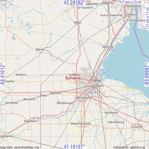
Sylvania GPS coordinates[2]
41° 43' 8.184" North, 83° 42' 46.764" West
| Map corner | latitude | longitude |
|---|---|---|
| Upper-left | 42.24162°, | -84.41612° |
| Center: | 41.71894°, | -83.71299° |
| Lower-right: | 41.19197°, | -83.00987° |
| Map W x H: | 116.7×116.7 km | = 72.5×72.5mi |
| max Lat: | 71.29058° ⇑26.9% North |
| Sylvania: | 41.71894° |
| min Lat: | ⇓73.1% South 19.06759° |
| min Long | Sylvania | max Long |
| -171.73463° | -83.71299° | -66.98998° |
| W 60.1%⇐ | ⇒39.9% E |
Elevation
Elevation of Sylvania is 207 m = 679 ft, and this is 87.8 m = 288 ft below average elevation for this country.
| Max E: |
3189 m = 10463 ft | 47.8% |
| Avg. | 294.8 m = 967 ft | |
| Sylvania | 207 m = 679 ft | |
Min E: |
-60 m = -197 ft | 52.2% |
See also: United States elevation on elevation.city.
Geographical zone
Sylvania is located in North temperate zone (between Tropic of Cancer and the Arctic Circle). Distance of this Northern Tropic circle is 2032.8 km =1263.1 mi to South.| Distance of | km | miles | from Sylvania |
|---|---|---|---|
| North Pole | 5368.4 | 3335.8 | to North |
| Arctic Circle | 2762.5 | 1716.5 | to North |
| Tropic Cancer | 2032.8 | 1263.1 | to South |
| Equator | 4638.7 | 2882.4 | to South |


Nearby cities:
15 places around Sylvania: (largest is in red/bold)
• Blissfield
17.7 km =11 mi,  315°
315°
• Deerfield
19.7 km =12.2 mi,  343°
343°
• Holland
10.8 km =6.7 mi,  179°
179°
• Lambertville
8.8 km =5.5 mi,  53°
53°
• Maumee
18 km =11.2 mi,  164°
164°
• Metamora
16.3 km =10.1 mi,  267°
267°
• Oregon
20.6 km =12.8 mi,  114°
114°
• Ottawa Hills
8.4 km =5.2 mi,  136°
136°
• Perrysburg
19.4 km =12.1 mi, 158°
• Petersburg
20.3 km =12.6 mi,  359°
359°
• Rossford
17.3 km =10.7 mi,  134°
134°
• Swanton
20.7 km =12.9 mi,  225°
225°
• Temperance
13.7 km =8.5 mi,  60°
60°
• Toledo
14.5 km =9 mi,  115°
115°
• Walbridge
23.4 km =14.5 mi, 128°
Sources, notices
• [Note1] Compared only with cities in United States existing in our database
• [Src1] Map data: © OpenStreetMap contributors (CC-BY-SA)
• [Src2] Other city data from geonames.org with taken over terms of usage.
• [Src3] Geographical zone / Annual Mean Temperature by Robert A. Rohde @ Wikipedia
