Westfield Center geodata
Westfield Center (Ohio) is a populated place; located in United States in America/New_York (GMT-4) time zone. With population of 1,134 people, there are 15474 cities with bigger population in this country. Compared to other cities in United States, 66.2% of cities are located further ↓South; 65.8% of cities are located further ←West and 78.5% of cities have lower elevation than Westfield Center. Note1
Administrative division(s):
- Level 1: Ohio
- Level 2: Medina County
- Level 3: Village of Westfield Center


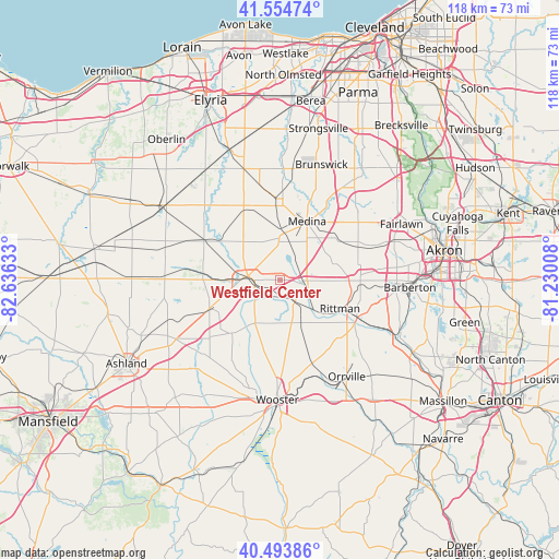
Westfield Center GPS coordinates[2]
41° 1' 35.184" North, 81° 55' 59.52" West
| Map corner | latitude | longitude |
|---|---|---|
| Upper-left | 41.55474°, | -82.63633° |
| Center: | 41.02644°, | -81.9332° |
| Lower-right: | 40.49386°, | -81.23008° |
| Map W x H: | 118×118 km | = 73.3×73.3mi |
| max Lat: | 71.29058° ⇑33.8% North |
| Westfield Center: | 41.02644° |
| min Lat: | ⇓66.2% South 19.06759° |
| min Long | Westfield Cente | max Long |
| -171.73463° | -81.9332° | -66.98998° |
| W 65.8%⇐ | ⇒34.2% E |
Elevation
Elevation of Westfield Center is 340 m = 1115 ft, and this is 45.2 m = 148 ft above average elevation for this country.
| Max E: |
3189 m = 10463 ft | 21.5% |
| Westfield Center | 340 m 1115 ft | |
| Avg. | 294.8 m = 967 ft | |
Min E: |
-60 m = -197 ft | 78.5% |
See also: United States elevation on elevation.city.
Geographical zone
Westfield Center is located in North temperate zone (between Tropic of Cancer and the Arctic Circle). Distance of this Northern Tropic circle is 1955.8 km =1215.3 mi to South.| Distance of | km | miles | from Westfield Center |
|---|---|---|---|
| North Pole | 5445.3 | 3383.6 | to North |
| Arctic Circle | 2839.5 | 1764.4 | to North |
| Tropic Cancer | 1955.8 | 1215.3 | to South |
| Equator | 4561.7 | 2834.5 | to South |


Nearby cities:
15 places around Westfield Center: (largest is in red/bold)
• Briarwood Beach
6.4 km =4 mi,  28°
28°
• Chippewa Lake
5.5 km =3.4 mi, 29°
• Creston
5.5 km =3.4 mi,  142°
142°
• Doylestown
20.8 km =12.9 mi,  107°
107°
• Lodi
6.7 km =4.2 mi,  276°
276°
• Marshallville
21.7 km =13.5 mi,  129°
129°
• Medina
13.7 km =8.5 mi, 25°
• Pigeon Creek
23.8 km =14.8 mi,  66°
66°
• Rittman
13.8 km =8.6 mi, 112°
• Seville
6.2 km =3.9 mi, 107°
• Smithville
19.2 km =11.9 mi,  161°
161°
• Spencer
17.9 km =11.1 mi,  297°
297°
• Wadsworth
17.1 km =10.6 mi,  90°
90°
• West Salem
16 km =9.9 mi,  247°
247°
• Wooster
24.6 km =15.3 mi,  180°
180°
Sources, notices
• [Note1] Compared only with cities in United States existing in our database
• [Src1] Map data: © OpenStreetMap contributors (CC-BY-SA)
• [Src2] Other city data from geonames.org with taken over terms of usage.
• [Src3] Geographical zone / Annual Mean Temperature by Robert A. Rohde @ Wikipedia
