Wooster geodata
Wooster (Ohio) is a seat of a second-order administrative division; located in United States in America/New_York (GMT-4) time zone. With population of 26,749 people, there are 1873 cities with bigger population in this country. Compared to other cities in United States, 63.3% of cities are located further ↓South; 65.7% of cities are located further ←West and 73.3% of cities have lower elevation than Wooster. Note1


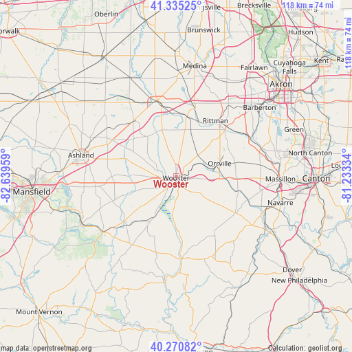
Wooster GPS coordinates[2]
40° 48' 18.612" North, 81° 56' 11.256" West
| Map corner | latitude | longitude |
|---|---|---|
| Upper-left | 41.33525°, | -82.63959° |
| Center: | 40.80517°, | -81.93646° |
| Lower-right: | 40.27082°, | -81.23334° |
| Map W x H: | 118.4×118.4 km | = 73.6×73.6mi |
| max Lat: | 71.29058° ⇑36.7% North |
| Wooster: | 40.80517° |
| min Lat: | ⇓63.3% South 19.06759° |
| min Long | Wooster | max Long |
| -171.73463° | -81.93646° | -66.98998° |
| W 65.7%⇐ | ⇒34.3% E |
Elevation
Elevation of Wooster is 303 m = 994 ft, and this is 8.2 m = 27 ft above average elevation for this country.
| Max E: |
3189 m = 10463 ft | 26.7% |
| Wooster | 303 m 994 ft | |
| Avg. | 294.8 m = 967 ft | |
Min E: |
-60 m = -197 ft | 73.3% |
See also: United States elevation on elevation.city.
Geographical zone
Wooster is located in North temperate zone (between Tropic of Cancer and the Arctic Circle). Distance of this Northern Tropic circle is 1931.2 km =1200 mi to South.| Distance of | km | miles | from Wooster |
|---|---|---|---|
| North Pole | 5470 | 3398.9 | to North |
| Arctic Circle | 2864.1 | 1779.7 | to North |
| Tropic Cancer | 1931.2 | 1200 | to South |
| Equator | 4537.1 | 2819.2 | to South |


Nearby cities:
15 places around Wooster: (largest is in red/bold)
• Apple Creek
10.1 km =6.3 mi,  125°
125°
• Creston
20.5 km =12.7 mi,  10°
10°
• Dalton
20.3 km =12.6 mi,  91°
91°
• Doylestown
27.3 km =17 mi,  47°
47°
• Jeromesville
21.8 km =13.5 mi,  269°
269°
• Kidron
17.6 km =10.9 mi,  113°
113°
• Lodi
26.2 km =16.3 mi,  345°
345°
• Marshallville
20.2 km =12.6 mi,  57°
57°
• Orrville
15.1 km =9.4 mi,  73°
73°
• Rittman
23.2 km =14.4 mi,  34°
34°
• Seville
23.6 km =14.7 mi,  15°
15°
• Shreve
15.5 km =9.6 mi,  207°
207°
• Smithville
8.9 km =5.5 mi,  44°
44°
• West Salem
23.5 km =14.6 mi,  321°
321°
• Westfield Center
24.6 km =15.3 mi,  0°
0°
Sources, notices
• [Note1] Compared only with cities in United States existing in our database
• [Src1] Map data: © OpenStreetMap contributors (CC-BY-SA)
• [Src2] Other city data from geonames.org with taken over terms of usage.
• [Src3] Geographical zone / Annual Mean Temperature by Robert A. Rohde @ Wikipedia
