Bellefonte geodata
Bellefonte (Pennsylvania) is a seat of a second-order administrative division; located in United States in America/New_York (GMT-4) time zone. With population of 6,248 people, there are 6241 cities with bigger population in this country. Compared to other cities in United States, 64.9% of cities are located further ↓South; 78.2% of cities are located further ←West and 60.1% of cities have lower elevation than Bellefonte. Note1
Administrative division(s):
- Level 1: Pennsylvania
- Level 2: Centre County
- Level 3: Borough of Bellefonte


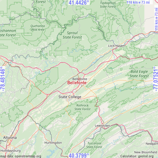
Bellefonte GPS coordinates[2]
40° 54' 48.204" North, 77° 46' 41.988" West
| Map corner | latitude | longitude |
|---|---|---|
| Upper-left | 41.4426°, | -78.48146° |
| Center: | 40.91339°, | -77.77833° |
| Lower-right: | 40.3799°, | -77.07521° |
| Map W x H: | 118.2×118.2 km | = 73.4×73.4mi |
| max Lat: | 71.29058° ⇑35.1% North |
| Bellefonte: | 40.91339° |
| min Lat: | ⇓64.9% South 19.06759° |
| min Long | Bellefonte | max Long |
| -171.73463° | -77.77833° | -66.98998° |
| W 78.2%⇐ | ⇒21.8% E |
Elevation
Elevation of Bellefonte is 240 m = 787 ft, and this is 54.8 m = 180 ft below average elevation for this country.
| Max E: |
3189 m = 10463 ft | 39.9% |
| Avg. | 294.8 m = 967 ft | |
| Bellefonte | 240 m = 787 ft | |
Min E: |
-60 m = -197 ft | 60.1% |
See also: United States elevation on elevation.city.
Geographical zone
Bellefonte is located in North temperate zone (between Tropic of Cancer and the Arctic Circle). Distance of this Northern Tropic circle is 1943.2 km =1207.4 mi to South.| Distance of | km | miles | from Bellefonte |
|---|---|---|---|
| North Pole | 5457.9 | 3391.4 | to North |
| Arctic Circle | 2852 | 1772.2 | to North |
| Tropic Cancer | 1943.2 | 1207.4 | to South |
| Equator | 4549.1 | 2826.7 | to South |


Nearby cities:
15 places around Bellefonte: (largest is in red/bold)
• Boalsburg
15.4 km =9.6 mi,  184°
184°
• Centre Hall
10.7 km =6.6 mi,  133°
133°
• Clarence
20.2 km =12.6 mi,  317°
317°
• Houserville
10.8 km =6.7 mi,  203°
203°
• Howard
15.1 km =9.4 mi,  42°
42°
• Lemont
11.9 km =7.4 mi, 196°
• Milesburg
3.2 km =2 mi,  349°
349°
• Mingoville
11.1 km =6.9 mi,  79°
79°
• Nittany
20.9 km =13 mi,  63°
63°
• Park Forest Village
16.6 km =10.3 mi,  224°
224°
• Pleasant Gap
5.7 km =3.5 mi,  152°
152°
• Snow Shoe
19.4 km =12.1 mi,  312°
312°
• State College
15 km =9.3 mi,  207°
207°
• Toftrees
13 km =8.1 mi, 221°
• Zion
7.9 km =4.9 mi,  89°
89°
Sources, notices
• [Note1] Compared only with cities in United States existing in our database
• [Src1] Map data: © OpenStreetMap contributors (CC-BY-SA)
• [Src2] Other city data from geonames.org with taken over terms of usage.
• [Src3] Geographical zone / Annual Mean Temperature by Robert A. Rohde @ Wikipedia
