Bethel Park geodata
Bethel Park (Pennsylvania) is a populated place; located in United States in America/New_York (GMT-4) time zone. With population of 32,118 people, there are 1556 cities with bigger population in this country. Compared to other cities in United States, 57% of cities are located further ↓South; 73.1% of cities are located further ←West and 81% of cities have lower elevation than Bethel Park. Note1


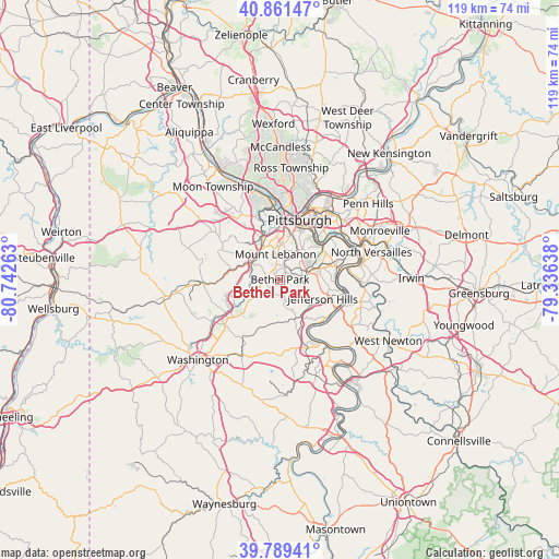
Bethel Park GPS coordinates[2]
40° 19' 39.252" North, 80° 2' 22.2" West
| Map corner | latitude | longitude |
|---|---|---|
| Upper-left | 40.86147°, | -80.74263° |
| Center: | 40.32757°, | -80.0395° |
| Lower-right: | 39.78941°, | -79.33638° |
| Map W x H: | 119.2×119.2 km | = 74.1×74.1mi |
| max Lat: | 71.29058° ⇑43% North |
| Bethel Park: | 40.32757° |
| min Lat: | ⇓57% South 19.06759° |
| min Long | Bethel Park | max Long |
| -171.73463° | -80.0395° | -66.98998° |
| W 73.1%⇐ | ⇒26.9% E |
Elevation
Elevation of Bethel Park is 365 m = 1198 ft, and this is 70.2 m = 230 ft above average elevation for this country.
| Max E: |
3189 m = 10463 ft | 19% |
| Bethel Park | 365 m 1198 ft | |
| Avg. | 294.8 m = 967 ft | |
Min E: |
-60 m = -197 ft | 81% |
See also: United States elevation on elevation.city.
Geographical zone
Bethel Park is located in North temperate zone (between Tropic of Cancer and the Arctic Circle). Distance of this Northern Tropic circle is 1878.1 km =1167 mi to South.| Distance of | km | miles | from Bethel Park |
|---|---|---|---|
| North Pole | 5523.1 | 3431.9 | to North |
| Arctic Circle | 2917.2 | 1812.7 | to North |
| Tropic Cancer | 1878.1 | 1167 | to South |
| Equator | 4484 | 2786.2 | to South |


Nearby cities:
15 places around Bethel Park: (largest is in red/bold)
• Baldwin
5.3 km =3.3 mi,  77°
77°
• Brentwood
7.3 km =4.5 mi,  48°
48°
• Bridgeville
6.8 km =4.2 mi,  298°
298°
• Bryn Mawr
4.8 km =3 mi,  236°
236°
• Castle Shannon
4.4 km =2.7 mi,  19°
19°
• Dormont
7.6 km =4.7 mi,  4°
4°
• Heidelberg
8.4 km =5.2 mi,  328°
328°
• Lawrence
7.3 km =4.5 mi,  250°
250°
• McMurray
6.7 km =4.2 mi,  214°
214°
• Mount Lebanon
3.2 km =2 mi,  344°
344°
• Pleasant Hills
6.7 km =4.2 mi, 82°
• South Park Township
5 km =3.1 mi,  129°
129°
• Thompsonville
7.1 km =4.4 mi,  234°
234°
• Upper Saint Clair
3.8 km =2.4 mi,  283°
283°
• Whitehall
5.6 km =3.5 mi, 47°
Sources, notices
• [Note1] Compared only with cities in United States existing in our database
• [Src1] Map data: © OpenStreetMap contributors (CC-BY-SA)
• [Src2] Other city data from geonames.org with taken over terms of usage.
• [Src3] Geographical zone / Annual Mean Temperature by Robert A. Rohde @ Wikipedia
