South Park Township geodata
South Park Township (Pennsylvania) is a populated place; located in United States in America/New_York (GMT-4) time zone. With population of 13,416 people, there are 3572 cities with bigger population in this country. Compared to other cities in United States, 56.6% of cities are located further ↓South; 73.3% of cities are located further ←West and 71.5% of cities have lower elevation than South Park Township. Note1
Administrative division(s):
- Level 1: Pennsylvania
- Level 2: Allegheny County
- Level 3: Township of South Park


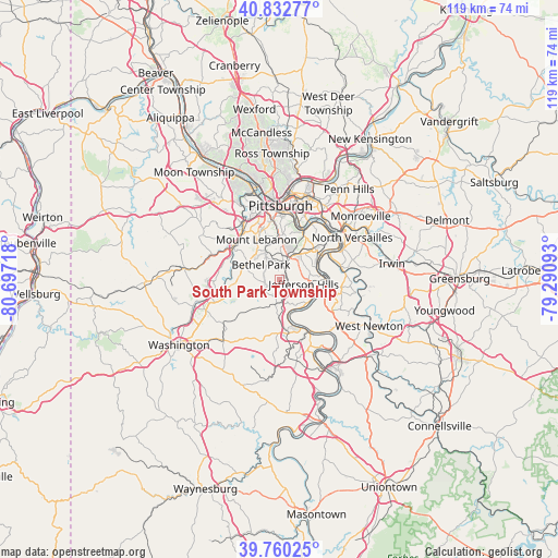
South Park Township GPS coordinates[2]
40° 17' 55.104" North, 79° 59' 38.58" West
| Map corner | latitude | longitude |
|---|---|---|
| Upper-left | 40.83277°, | -80.69718° |
| Center: | 40.29864°, | -79.99405° |
| Lower-right: | 39.76025°, | -79.29093° |
| Map W x H: | 119.3×119.3 km | = 74.1×74.1mi |
| max Lat: | 71.29058° ⇑43.4% North |
| South Park Township: | 40.29864° |
| min Lat: | ⇓56.6% South 19.06759° |
| min Long | South Park Town | max Long |
| -171.73463° | -79.99405° | -66.98998° |
| W 73.3%⇐ | ⇒26.7% E |
Elevation
Elevation of South Park Township is 293 m = 961 ft, and this is 1.8 m = 6 ft below average elevation for this country.
| Max E: |
3189 m = 10463 ft | 28.5% |
| Avg. | 294.8 m = 967 ft | |
| South Park Township | 293 m = 961 ft | |
Min E: |
-60 m = -197 ft | 71.5% |
See also: United States elevation on elevation.city.
Geographical zone
South Park Township is located in North temperate zone (between Tropic of Cancer and the Arctic Circle). Distance of this Northern Tropic circle is 1874.9 km =1165 mi to South.| Distance of | km | miles | from South Park Township |
|---|---|---|---|
| North Pole | 5526.3 | 3433.9 | to North |
| Arctic Circle | 2920.4 | 1814.7 | to North |
| Tropic Cancer | 1874.9 | 1165 | to South |
| Equator | 4480.8 | 2784.2 | to South |


Nearby cities:
15 places around South Park Township: (largest is in red/bold)
• Baldwin
4.6 km =2.9 mi,  16°
16°
• Bethel Park
5 km =3.1 mi,  309°
309°
• Brentwood
8.2 km =5.1 mi,  11°
11°
• Bryn Mawr
7.9 km =4.9 mi,  274°
274°
• Castle Shannon
7.7 km =4.8 mi,  341°
341°
• Gastonville
4.6 km =2.9 mi,  181°
181°
• Glassport
9.1 km =5.7 mi,  71°
71°
• Jefferson Hills
5.3 km =3.3 mi,  98°
98°
• McMurray
8 km =5 mi,  253°
253°
• Mount Lebanon
7.9 km =4.9 mi,  323°
323°
• Pleasant Hills
5 km =3.1 mi,  34°
34°
• Upper Saint Clair
8.6 km =5.3 mi,  298°
298°
• West Elizabeth
8.6 km =5.3 mi,  110°
110°
• Whitehall
7 km =4.3 mi,  2°
2°
• Wilson
8.8 km =5.5 mi,  81°
81°
Sources, notices
• [Note1] Compared only with cities in United States existing in our database
• [Src1] Map data: © OpenStreetMap contributors (CC-BY-SA)
• [Src2] Other city data from geonames.org with taken over terms of usage.
• [Src3] Geographical zone / Annual Mean Temperature by Robert A. Rohde @ Wikipedia
