Campbelltown geodata
Campbelltown (Pennsylvania) is a populated place; located in United States in America/New_York (GMT-4) time zone. With population of 3,616 people, there are 8702 cities with bigger population in this country. Compared to other cities in United States, 56.4% of cities are located further ↓South; 82.3% of cities are located further ←West and 62.9% of cities have higher elevation than Campbelltown. Note1
Administrative division(s):
- Level 1: Pennsylvania
- Level 2: Lebanon County
- Level 3: Township of South Londonderry


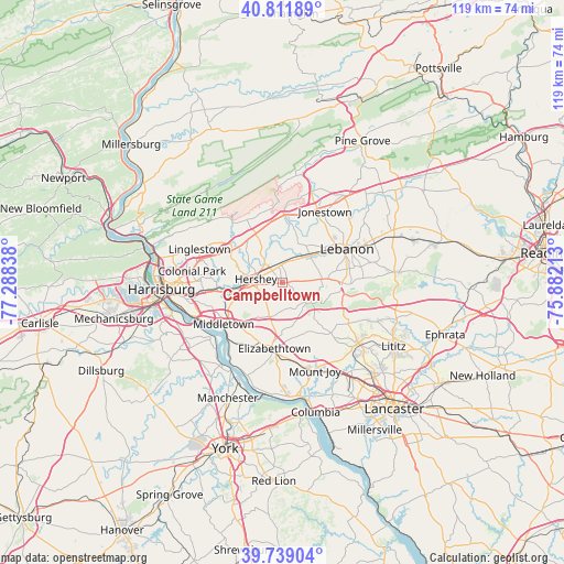
Campbelltown GPS coordinates[2]
40° 16' 39.324" North, 76° 35' 6.9" West
| Map corner | latitude | longitude |
|---|---|---|
| Upper-left | 40.81189°, | -77.28838° |
| Center: | 40.27759°, | -76.58525° |
| Lower-right: | 39.73904°, | -75.88213° |
| Map W x H: | 119.3×119.3 km | = 74.1×74.1mi |
| max Lat: | 71.29058° ⇑43.6% North |
| Campbelltown: | 40.27759° |
| min Lat: | ⇓56.4% South 19.06759° |
| min Long | Campbelltown | max Long |
| -171.73463° | -76.58525° | -66.98998° |
| W 82.3%⇐ | ⇒17.7% E |
Elevation
Elevation of Campbelltown is 139 m = 456 ft, and this is 155.8 m = 511 ft below average elevation for this country.
| Max E: |
3189 m = 10463 ft | 62.9% |
| Avg. | 294.8 m = 967 ft | |
| Campbelltown | 139 m = 456 ft | |
Min E: |
-60 m = -197 ft | 37.1% |
See also: United States elevation on elevation.city.
Geographical zone
Campbelltown is located in North temperate zone (between Tropic of Cancer and the Arctic Circle). Distance of this Northern Tropic circle is 1872.5 km =1163.5 mi to South.| Distance of | km | miles | from Campbelltown |
|---|---|---|---|
| North Pole | 5528.6 | 3435.3 | to North |
| Arctic Circle | 2922.7 | 1816.1 | to North |
| Tropic Cancer | 1872.5 | 1163.5 | to South |
| Equator | 4478.4 | 2782.7 | to South |


Nearby cities:
15 places around Campbelltown: (largest is in red/bold)
• Annville
8.3 km =5.2 mi,  45°
45°
• Cleona
11.4 km =7.1 mi, 54°
• Cornwall
15.2 km =9.4 mi,  91°
91°
• Elizabethtown
13.9 km =8.6 mi,  186°
186°
• Hershey
5.6 km =3.5 mi,  279°
279°
• Hummelstown
10.5 km =6.5 mi,  262°
262°
• Middletown
15.1 km =9.4 mi,  235°
235°
• Palmdale
3.6 km =2.2 mi,  308°
308°
• Palmyra
3.6 km =2.2 mi,  348°
348°
• Pleasant Hill
13.8 km =8.6 mi,  61°
61°
• Quentin
12.4 km =7.7 mi, 88°
• Royalton
15.9 km =9.9 mi,  230°
230°
• Rutherford
15.5 km =9.6 mi,  266°
266°
• Sand Hill
15.9 km =9.9 mi, 55°
• Skyline View
13.7 km =8.5 mi,  299°
299°
Sources, notices
• [Note1] Compared only with cities in United States existing in our database
• [Src1] Map data: © OpenStreetMap contributors (CC-BY-SA)
• [Src2] Other city data from geonames.org with taken over terms of usage.
• [Src3] Geographical zone / Annual Mean Temperature by Robert A. Rohde @ Wikipedia
