Skyline View geodata
Skyline View (Pennsylvania) is a populated place; located in United States in America/New_York (GMT-4) time zone. With population of 4,003 people, there are 8213 cities with bigger population in this country. Compared to other cities in United States, 57.2% of cities are located further ↓South; 81.8% of cities are located further ←West and 59.5% of cities have higher elevation than Skyline View. Note1
Administrative division(s):
- Level 1: Pennsylvania
- Level 2: Dauphin County
- Level 3: Township of West Hanover


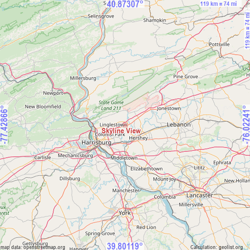
Skyline View GPS coordinates[2]
40° 20' 21.336" North, 76° 43' 31.908" West
| Map corner | latitude | longitude |
|---|---|---|
| Upper-left | 40.87307°, | -77.42866° |
| Center: | 40.33926°, | -76.72553° |
| Lower-right: | 39.80119°, | -76.02241° |
| Map W x H: | 119.2×119.2 km | = 74.1×74.1mi |
| max Lat: | 71.29058° ⇑42.8% North |
| Skyline View: | 40.33926° |
| min Lat: | ⇓57.2% South 19.06759° |
| min Long | Skyline View | max Long |
| -171.73463° | -76.72553° | -66.98998° |
| W 81.8%⇐ | ⇒18.2% E |
Elevation
Elevation of Skyline View is 157 m = 515 ft, and this is 137.8 m = 452 ft below average elevation for this country.
| Max E: |
3189 m = 10463 ft | 59.5% |
| Avg. | 294.8 m = 967 ft | |
| Skyline View | 157 m = 515 ft | |
Min E: |
-60 m = -197 ft | 40.5% |
See also: United States elevation on elevation.city.
Geographical zone
Skyline View is located in North temperate zone (between Tropic of Cancer and the Arctic Circle). Distance of this Northern Tropic circle is 1879.4 km =1167.8 mi to South.| Distance of | km | miles | from Skyline View |
|---|---|---|---|
| North Pole | 5521.8 | 3431.1 | to North |
| Arctic Circle | 2915.9 | 1811.9 | to North |
| Tropic Cancer | 1879.4 | 1167.8 | to South |
| Equator | 4485.3 | 2787 | to South |


Nearby cities:
15 places around Skyline View: (largest is in red/bold)
• Campbelltown
13.7 km =8.5 mi,  119°
119°
• Colonial Park
8.3 km =5.2 mi,  238°
238°
• Hershey
8.7 km =5.4 mi,  132°
132°
• Hummelstown
8.3 km =5.2 mi,  169°
169°
• Lawnton
11.2 km =7 mi,  216°
216°
• Lawrence Park
6.4 km =4 mi,  276°
276°
• Linglestown
5.4 km =3.4 mi,  263°
263°
• Oberlin
13.2 km =8.2 mi,  214°
214°
• Palmdale
10.2 km =6.3 mi, 116°
• Palmyra
11.7 km =7.3 mi,  106°
106°
• Paxtang
12.7 km =7.9 mi,  225°
225°
• Paxtonia
6.3 km =3.9 mi,  247°
247°
• Penbrook
12.6 km =7.8 mi, 235°
• Progress
10.8 km =6.7 mi, 236°
• Rutherford
8.6 km =5.3 mi,  204°
204°
Sources, notices
• [Note1] Compared only with cities in United States existing in our database
• [Src1] Map data: © OpenStreetMap contributors (CC-BY-SA)
• [Src2] Other city data from geonames.org with taken over terms of usage.
• [Src3] Geographical zone / Annual Mean Temperature by Robert A. Rohde @ Wikipedia
