Delmont geodata
Delmont (Pennsylvania) is a populated place; located in United States in America/New_York (GMT-4) time zone. With population of 2,640 people, there are 10307 cities with bigger population in this country. Compared to other cities in United States, 58% of cities are located further ↓South; 74.7% of cities are located further ←West and 82.5% of cities have lower elevation than Delmont. Note1
Administrative division(s):
- Level 1: Pennsylvania
- Level 2: Westmoreland County
- Level 3: Borough of Delmont


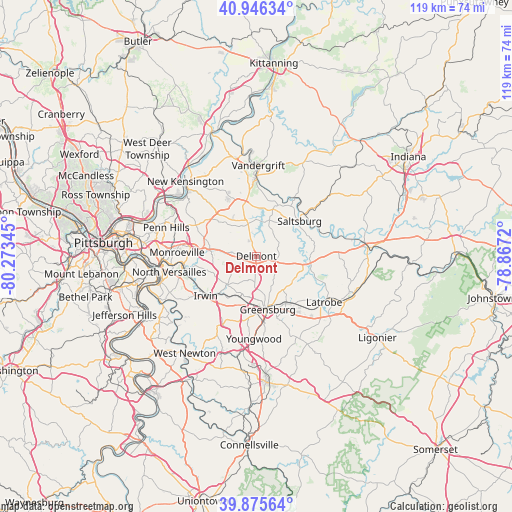
Delmont GPS coordinates[2]
40° 24' 47.232" North, 79° 34' 13.152" West
| Map corner | latitude | longitude |
|---|---|---|
| Upper-left | 40.94634°, | -80.27345° |
| Center: | 40.41312°, | -79.57032° |
| Lower-right: | 39.87564°, | -78.8672° |
| Map W x H: | 119.1×119 km | = 74×73.9mi |
| max Lat: | 71.29058° ⇑42% North |
| Delmont: | 40.41312° |
| min Lat: | ⇓58% South 19.06759° |
| min Long | Delmont | max Long |
| -171.73463° | -79.57032° | -66.98998° |
| W 74.7%⇐ | ⇒25.3% E |
Elevation
Elevation of Delmont is 382 m = 1253 ft, and this is 87.2 m = 286 ft above average elevation for this country.
| Max E: |
3189 m = 10463 ft | 17.5% |
| Delmont | 382 m 1253 ft | |
| Avg. | 294.8 m = 967 ft | |
Min E: |
-60 m = -197 ft | 82.5% |
See also: United States elevation on elevation.city.
Geographical zone
Delmont is located in North temperate zone (between Tropic of Cancer and the Arctic Circle). Distance of this Northern Tropic circle is 1887.6 km =1172.9 mi to South.| Distance of | km | miles | from Delmont |
|---|---|---|---|
| North Pole | 5513.5 | 3425.9 | to North |
| Arctic Circle | 2907.7 | 1806.8 | to North |
| Tropic Cancer | 1887.6 | 1172.9 | to South |
| Equator | 4493.5 | 2792.1 | to South |


Nearby cities:
15 places around Delmont: (largest is in red/bold)
• Avonmore
15.8 km =9.8 mi,  35°
35°
• Export
4.7 km =2.9 mi,  276°
276°
• Grapeville
10.2 km =6.3 mi,  197°
197°
• Greensburg
12.7 km =7.9 mi,  167°
167°
• Irwin
14.8 km =9.2 mi,  228°
228°
• Jeannette
10.2 km =6.3 mi, 201°
• Level Green
12.9 km =8 mi,  260°
260°
• Manor
12.2 km =7.6 mi,  223°
223°
• Murrysville
10.9 km =6.8 mi, 278°
• New Alexandria
12.7 km =7.9 mi,  97°
97°
• North Irwin
14.7 km =9.1 mi,  235°
235°
• Saltsburg
12.9 km =8 mi,  50°
50°
• South Greensburg
15.1 km =9.4 mi, 171°
• Southwest Greensburg
13.7 km =8.5 mi, 171°
• Trafford
16.3 km =10.1 mi, 259°
Sources, notices
• [Note1] Compared only with cities in United States existing in our database
• [Src1] Map data: © OpenStreetMap contributors (CC-BY-SA)
• [Src2] Other city data from geonames.org with taken over terms of usage.
• [Src3] Geographical zone / Annual Mean Temperature by Robert A. Rohde @ Wikipedia
