Heilwood geodata
Heilwood (Pennsylvania) is a populated place; located in United States in America/New_York (GMT-4) time zone. With population of 711 people, there are 18575 cities with bigger population in this country. Compared to other cities in United States, 60.3% of cities are located further ↓South; 75.9% of cities are located further ←West and 88.7% of cities have lower elevation than Heilwood. Note1


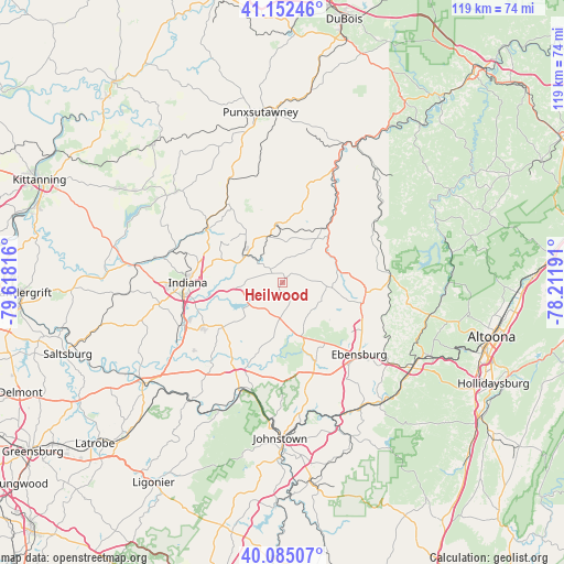
Heilwood GPS coordinates[2]
40° 37' 15.24" North, 78° 54' 54.108" West
| Map corner | latitude | longitude |
|---|---|---|
| Upper-left | 41.15246°, | -79.61816° |
| Center: | 40.6209°, | -78.91503° |
| Lower-right: | 40.08507°, | -78.21191° |
| Map W x H: | 118.7×118.7 km | = 73.8×73.8mi |
| max Lat: | 71.29058° ⇑39.7% North |
| Heilwood: | 40.6209° |
| min Lat: | ⇓60.3% South 19.06759° |
| min Long | Heilwood | max Long |
| -171.73463° | -78.91503° | -66.98998° |
| W 75.9%⇐ | ⇒24.1% E |
Elevation
Elevation of Heilwood is 539 m = 1768 ft, and this is 244.2 m = 801 ft above average elevation for this country.
| Max E: |
3189 m = 10463 ft | 11.3% |
| Heilwood | 539 m 1768 ft | |
| Avg. | 294.8 m = 967 ft | |
Min E: |
-60 m = -197 ft | 88.7% |
See also: United States elevation on elevation.city.
Geographical zone
Heilwood is located in North temperate zone (between Tropic of Cancer and the Arctic Circle). Distance of this Northern Tropic circle is 1910.7 km =1187.3 mi to South.| Distance of | km | miles | from Heilwood |
|---|---|---|---|
| North Pole | 5490.4 | 3411.6 | to North |
| Arctic Circle | 2884.6 | 1792.4 | to North |
| Tropic Cancer | 1910.7 | 1187.3 | to South |
| Equator | 4516.6 | 2806.5 | to South |


Nearby cities:
15 places around Heilwood: (largest is in red/bold)
• Barnesboro
12.3 km =7.6 mi,  67°
67°
• Carrolltown
17.5 km =10.9 mi,  96°
96°
• Chevy Chase Heights
19.4 km =12.1 mi,  275°
275°
• Clymer
9.7 km =6 mi,  302°
302°
• Colver
13.8 km =8.6 mi,  128°
128°
• Ebensburg
22.1 km =13.7 mi, 133°
• Hastings
17.8 km =11.1 mi, 73°
• Indiana
20 km =12.4 mi,  270°
270°
• Lucerne Mines
21.1 km =13.1 mi,  250°
250°
• Mundys Corner
20.6 km =12.8 mi,  162°
162°
• Nanty Glo
17.9 km =11.1 mi, 157°
• Northern Cambria
12 km =7.5 mi, 69°
• Patton
22.4 km =13.9 mi,  86°
86°
• Revloc
19.2 km =11.9 mi,  138°
138°
• Spangler
12.2 km =7.6 mi,  78°
78°
Sources, notices
• [Note1] Compared only with cities in United States existing in our database
• [Src1] Map data: © OpenStreetMap contributors (CC-BY-SA)
• [Src2] Other city data from geonames.org with taken over terms of usage.
• [Src3] Geographical zone / Annual Mean Temperature by Robert A. Rohde @ Wikipedia
