Indiana geodata
Indiana (Pennsylvania) is a seat of a second-order administrative division; located in United States in America/New_York (GMT-4) time zone. With population of 14,100 people, there are 3416 cities with bigger population in this country. Compared to other cities in United States, 60.3% of cities are located further ↓South; 75.4% of cities are located further ←West and 83.9% of cities have lower elevation than Indiana. Note1
Administrative division(s):
- Level 1: Pennsylvania
- Level 2: Indiana County
- Level 3: Borough of Indiana


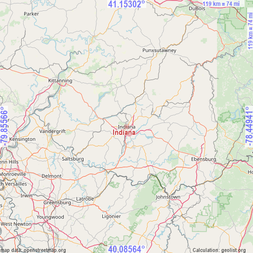
Indiana GPS coordinates[2]
40° 37' 17.256" North, 79° 9' 9.108" West
| Map corner | latitude | longitude |
|---|---|---|
| Upper-left | 41.15302°, | -79.85566° |
| Center: | 40.62146°, | -79.15253° |
| Lower-right: | 40.08564°, | -78.44941° |
| Map W x H: | 118.7×118.7 km | = 73.8×73.8mi |
| max Lat: | 71.29058° ⇑39.7% North |
| Indiana: | 40.62146° |
| min Lat: | ⇓60.3% South 19.06759° |
| min Long | Indiana | max Long |
| -171.73463° | -79.15253° | -66.98998° |
| W 75.4%⇐ | ⇒24.6% E |
Elevation
Elevation of Indiana is 403 m = 1322 ft, and this is 108.2 m = 355 ft above average elevation for this country.
| Max E: |
3189 m = 10463 ft | 16.1% |
| Indiana | 403 m 1322 ft | |
| Avg. | 294.8 m = 967 ft | |
Min E: |
-60 m = -197 ft | 83.9% |
See also: United States elevation on elevation.city.
Geographical zone
Indiana is located in North temperate zone (between Tropic of Cancer and the Arctic Circle). Distance of this Northern Tropic circle is 1910.8 km =1187.3 mi to South.| Distance of | km | miles | from Indiana |
|---|---|---|---|
| North Pole | 5490.4 | 3411.6 | to North |
| Arctic Circle | 2884.5 | 1792.3 | to North |
| Tropic Cancer | 1910.8 | 1187.3 | to South |
| Equator | 4516.7 | 2806.5 | to South |


Nearby cities:
15 places around Indiana: (largest is in red/bold)
• Avonmore
28 km =17.4 mi,  248°
248°
• Black Lick
16.8 km =10.4 mi,  189°
189°
• Blairsville
23.1 km =14.4 mi,  203°
203°
• Chevy Chase Heights
1.8 km =1.1 mi,  22°
22°
• Clymer
13 km =8.1 mi,  66°
66°
• Dayton
29.8 km =18.5 mi,  345°
345°
• Heilwood
20 km =12.4 mi,  90°
90°
• Homer City
8.7 km =5.4 mi, 185°
• Jacksonville
14.1 km =8.8 mi,  230°
230°
• Lucerne Mines
7 km =4.3 mi,  179°
179°
• New Florence
27.6 km =17.1 mi,  166°
166°
• Northern Cambria
31.6 km =19.6 mi,  82°
82°
• Robinson
24.2 km =15 mi, 177°
• Rural Valley
24 km =14.9 mi,  325°
325°
• Saltsburg
29.4 km =18.3 mi,  239°
239°
Sources, notices
• [Note1] Compared only with cities in United States existing in our database
• [Src1] Map data: © OpenStreetMap contributors (CC-BY-SA)
• [Src2] Other city data from geonames.org with taken over terms of usage.
• [Src3] Geographical zone / Annual Mean Temperature by Robert A. Rohde @ Wikipedia
