Jim Thorpe geodata
Jim Thorpe (Pennsylvania) is a seat of a second-order administrative division; located in United States in America/New_York (GMT-4) time zone. With population of 4,641 people, there are 7501 cities with bigger population in this country. Compared to other cities in United States, 64.3% of cities are located further ↓South; 84.9% of cities are located further ←West and 56.1% of cities have lower elevation than Jim Thorpe. Note1
Administrative division(s):
- Level 1: Pennsylvania
- Level 2: Carbon County
- Level 3: Borough of Jim Thorpe


Jim Thorpe GPS coordinates[2]
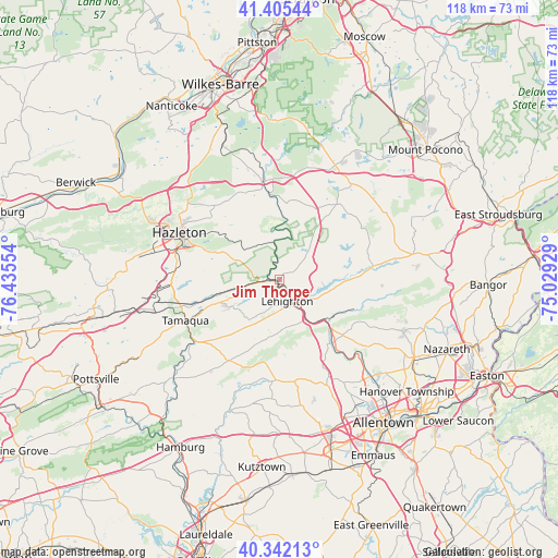
40° 52' 33.312" North, 75° 43' 56.676" West
| Map corner | latitude | longitude |
|---|---|---|
| Upper-left | 41.40544°, | -76.43554° |
| Center: | 40.87592°, | -75.73241° |
| Lower-right: | 40.34213°, | -75.02929° |
| Map W x H: | 118.2×118.2 km | = 73.4×73.4mi |
| max Lat: | 71.29058° ⇑35.7% North |
| Jim Thorpe: | 40.87592° |
| min Lat: | ⇓64.3% South 19.06759° |
| min Long | Jim Thorpe | max Long |
| -171.73463° | -75.73241° | -66.98998° |
| W 84.9%⇐ | ⇒15.1% E |
Elevation
Elevation of Jim Thorpe is 223 m = 732 ft, and this is 71.8 m = 236 ft below average elevation for this country.
| Max E: |
3189 m = 10463 ft | 43.9% |
| Avg. | 294.8 m = 967 ft | |
| Jim Thorpe | 223 m = 732 ft | |
Min E: |
-60 m = -197 ft | 56.1% |
See also: United States elevation on elevation.city.
Geographical zone
Jim Thorpe is located in North temperate zone (between Tropic of Cancer and the Arctic Circle). Distance of this Northern Tropic circle is 1939.1 km =1204.9 mi to South.| Distance of | km | miles | from Jim Thorpe |
|---|---|---|---|
| North Pole | 5462.1 | 3394 | to North |
| Arctic Circle | 2856.2 | 1774.8 | to North |
| Tropic Cancer | 1939.1 | 1204.9 | to South |
| Equator | 4545 | 2824.1 | to South |


Nearby cities:
15 places around Jim Thorpe: (largest is in red/bold)
• Beaver Meadows
16.4 km =10.2 mi,  290°
290°
• Bowmanstown
10.3 km =6.4 mi,  144°
144°
• Coaldale
15.8 km =9.8 mi,  248°
248°
• Hickory Hills
19.4 km =12.1 mi,  337°
337°
• Lansford
13.5 km =8.4 mi, 248°
• Lehighton
4.9 km =3 mi,  161°
161°
• Nesquehoning
6.7 km =4.2 mi,  259°
259°
• Palmerton
13.1 km =8.1 mi,  129°
129°
• Parryville
8.2 km =5.1 mi, 141°
• Slatington
17.4 km =10.8 mi, 144°
• Summit Hill
13 km =8.1 mi,  244°
244°
• Towamensing Trails
19.2 km =11.9 mi,  40°
40°
• Walnutport
17.6 km =10.9 mi, 140°
• Weatherly
11 km =6.8 mi,  311°
311°
• Weissport East
5.8 km =3.6 mi, 138°
Sources, notices
• [Note1] Compared only with cities in United States existing in our database
• [Src1] Map data: © OpenStreetMap contributors (CC-BY-SA)
• [Src2] Other city data from geonames.org with taken over terms of usage.
• [Src3] Geographical zone / Annual Mean Temperature by Robert A. Rohde @ Wikipedia
