Lancaster geodata
Lancaster (Pennsylvania) is a seat of a second-order administrative division; located in United States in America/New_York (GMT-4) time zone. With population of 59,339 people, there are 759 cities with bigger population in this country. Compared to other cities in United States, 53.9% of cities are located further ↓South; 83.2% of cities are located further ←West and 67.3% of cities have higher elevation than Lancaster. Note1
Administrative division(s):
- Level 1: Pennsylvania
- Level 2: Lancaster County
- Level 3: City of Lancaster


Lancaster GPS coordinates[2]
40° 2' 16.368" North, 76° 18' 19.836" West
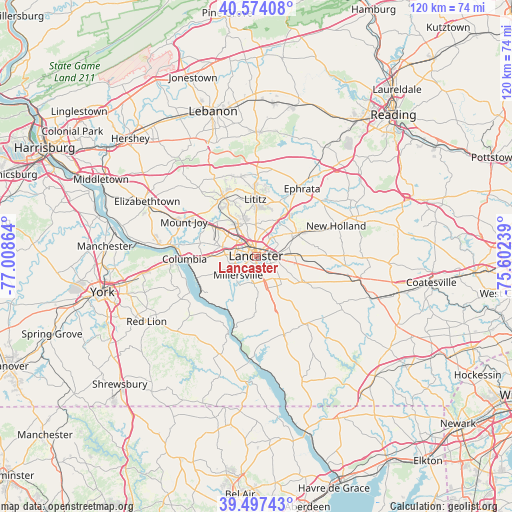
| Map corner | latitude | longitude |
|---|---|---|
| Upper-left | 40.57408°, | -77.00864° |
| Center: | 40.03788°, | -76.30551° |
| Lower-right: | 39.49743°, | -75.60239° |
| Map W x H: | 119.7×119.7 km | = 74.4×74.4mi |
| max Lat: | 71.29058° ⇑46.1% North |
| Lancaster: | 40.03788° |
| min Lat: | ⇓53.9% South 19.06759° |
| min Long | Lancaster | max Long |
| -171.73463° | -76.30551° | -66.98998° |
| W 83.2%⇐ | ⇒16.8% E |
Elevation
Elevation of Lancaster is 116 m = 381 ft, and this is 178.8 m = 587 ft below average elevation for this country.
| Max E: |
3189 m = 10463 ft | 67.3% |
| Avg. | 294.8 m = 967 ft | |
| Lancaster | 116 m = 381 ft | |
Min E: |
-60 m = -197 ft | 32.7% |
See also: Lancaster elevation on elevation.city.
Geographical zone
Lancaster is located in North temperate zone (between Tropic of Cancer and the Arctic Circle). Distance of this Northern Tropic circle is 1845.9 km =1147 mi to South.| Distance of | km | miles | from Lancaster |
|---|---|---|---|
| North Pole | 5555.3 | 3451.9 | to North |
| Arctic Circle | 2949.4 | 1832.7 | to North |
| Tropic Cancer | 1845.9 | 1147 | to South |
| Equator | 4451.8 | 2766.2 | to South |


Nearby cities:
15 places around Lancaster: (largest is in red/bold)
• Brownstown
12.3 km =7.6 mi,  39°
39°
• Conestoga
11.4 km =7.1 mi,  197°
197°
• East Petersburg
8.1 km =5 mi,  329°
329°
• Lampeter
7.7 km =4.8 mi,  133°
133°
• Landisville
10.9 km =6.8 mi,  305°
305°
• Leola
11.7 km =7.3 mi,  61°
61°
• Lititz
13.3 km =8.3 mi,  359°
359°
• Millersville
6.1 km =3.8 mi,  222°
222°
• Mountville
10.7 km =6.6 mi,  270°
270°
• Rothsville
13.4 km =8.3 mi,  20°
20°
• Salunga
12.3 km =7.6 mi,  304°
304°
• Soudersburg
13.1 km =8.1 mi,  101°
101°
• Strasburg
12 km =7.5 mi,  120°
120°
• Wheatland
3.9 km =2.4 mi, 272°
• Willow Street
7 km =4.3 mi,  159°
159°
Sources, notices
• [Note1] Compared only with cities in United States existing in our database
• [Src1] Map data: © OpenStreetMap contributors (CC-BY-SA)
• [Src2] Other city data from geonames.org with taken over terms of usage.
• [Src3] Geographical zone / Annual Mean Temperature by Robert A. Rohde @ Wikipedia
