Wheatland geodata
Wheatland (Pennsylvania) is a populated place; located in United States in America/New_York (GMT-4) time zone. With population of 723 people, there are 18471 cities with bigger population in this country. Compared to other cities in United States, 54% of cities are located further ↓South; 83% of cities are located further ←West and 69.6% of cities have higher elevation than Wheatland. Note1
Administrative division(s):
- Level 1: Pennsylvania
- Level 2: Lancaster County
- Level 3: Township of East Hempfield


Wheatland GPS coordinates[2]
40° 2' 22.344" North, 76° 21' 3.852" West
| Map corner | latitude | longitude |
|---|---|---|
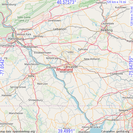
| Upper-left | 40.57573°, | -77.0542° |
| Center: | 40.03954°, | -76.35107° |
| Lower-right: | 39.4991°, | -75.64795° |
| Map W x H: | 119.7×119.7 km | = 74.4×74.4mi |
| max Lat: | 71.29058° ⇑46% North |
| Wheatland: | 40.03954° |
| min Lat: | ⇓54% South 19.06759° |
| min Long | Wheatland | max Long |
| -171.73463° | -76.35107° | -66.98998° |
| W 83%⇐ | ⇒17% E |
Elevation
Elevation of Wheatland is 103 m = 338 ft, and this is 191.8 m = 629 ft below average elevation for this country.
| Max E: |
3189 m = 10463 ft | 69.6% |
| Avg. | 294.8 m = 967 ft | |
| Wheatland | 103 m = 338 ft | |
Min E: |
-60 m = -197 ft | 30.4% |
See also: United States elevation on elevation.city.
Geographical zone
Wheatland is located in North temperate zone (between Tropic of Cancer and the Arctic Circle). Distance of this Northern Tropic circle is 1846.1 km =1147.1 mi to South.| Distance of | km | miles | from Wheatland |
|---|---|---|---|
| North Pole | 5555.1 | 3451.8 | to North |
| Arctic Circle | 2949.2 | 1832.5 | to North |
| Tropic Cancer | 1846.1 | 1147.1 | to South |
| Equator | 4452 | 2766.3 | to South |


Nearby cities:
15 places around Wheatland: (largest is in red/bold)
• Brownstown
15 km =9.3 mi,  51°
51°
• Columbia
13.1 km =8.1 mi,  267°
267°
• Conestoga
11 km =6.8 mi,  177°
177°
• East Petersburg
6.7 km =4.2 mi,  357°
357°
• Lampeter
11 km =6.8 mi,  120°
120°
• Lancaster
3.9 km =2.4 mi,  92°
92°
• Landisville
8 km =5 mi,  321°
321°
• Lititz
13.6 km =8.5 mi,  16°
16°
• Manheim
14.3 km =8.9 mi,  344°
344°
• Millersville
4.6 km =2.9 mi, 183°
• Mountville
6.8 km =4.2 mi, 269°
• Rothsville
15.1 km =9.4 mi,  34°
34°
• Salunga
9.3 km =5.8 mi, 317°
• Washington Boro
11.2 km =7 mi,  242°
242°
• Willow Street
9.2 km =5.7 mi,  136°
136°
Sources, notices
• [Note1] Compared only with cities in United States existing in our database
• [Src1] Map data: © OpenStreetMap contributors (CC-BY-SA)
• [Src2] Other city data from geonames.org with taken over terms of usage.
• [Src3] Geographical zone / Annual Mean Temperature by Robert A. Rohde @ Wikipedia
