Laureldale geodata
Laureldale (Pennsylvania) is a populated place; located in United States in America/New_York (GMT-4) time zone. With population of 3,883 people, there are 8353 cities with bigger population in this country. Compared to other cities in United States, 57.7% of cities are located further ↓South; 84.3% of cities are located further ←West and 67.1% of cities have higher elevation than Laureldale. Note1
Administrative division(s):
- Level 1: Pennsylvania
- Level 2: Berks County
- Level 3: Borough of Laureldale


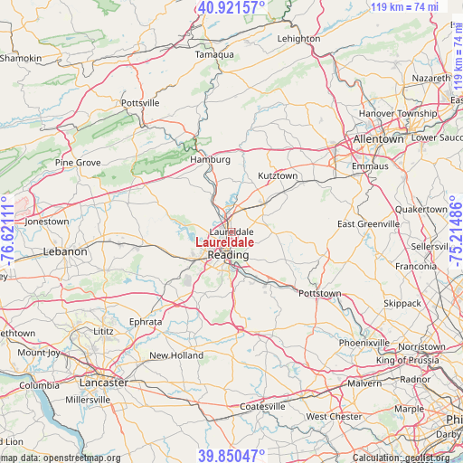
Laureldale GPS coordinates[2]
40° 23' 17.34" North, 75° 55' 4.728" West
| Map corner | latitude | longitude |
|---|---|---|
| Upper-left | 40.92157°, | -76.62111° |
| Center: | 40.38815°, | -75.91798° |
| Lower-right: | 39.85047°, | -75.21486° |
| Map W x H: | 119.1×119.1 km | = 74×74mi |
| max Lat: | 71.29058° ⇑42.3% North |
| Laureldale: | 40.38815° |
| min Lat: | ⇓57.7% South 19.06759° |
| min Long | Laureldale | max Long |
| -171.73463° | -75.91798° | -66.98998° |
| W 84.3%⇐ | ⇒15.7% E |
Elevation
Elevation of Laureldale is 117 m = 384 ft, and this is 177.8 m = 583 ft below average elevation for this country.
| Max E: |
3189 m = 10463 ft | 67.1% |
| Avg. | 294.8 m = 967 ft | |
| Laureldale | 117 m = 384 ft | |
Min E: |
-60 m = -197 ft | 32.9% |
See also: United States elevation on elevation.city.
Geographical zone
Laureldale is located in North temperate zone (between Tropic of Cancer and the Arctic Circle). Distance of this Northern Tropic circle is 1884.8 km =1171.2 mi to South.| Distance of | km | miles | from Laureldale |
|---|---|---|---|
| North Pole | 5516.3 | 3427.7 | to North |
| Arctic Circle | 2910.4 | 1808.4 | to North |
| Tropic Cancer | 1884.8 | 1171.2 | to South |
| Equator | 4490.7 | 2790.4 | to South |


Nearby cities:
15 places around Laureldale: (largest is in red/bold)
• Blandon
6.5 km =4 mi,  24°
24°
• Colony Park
7.1 km =4.4 mi,  229°
229°
• Fox Chase
3.8 km =2.4 mi,  282°
282°
• Greenfields
4.3 km =2.7 mi,  222°
222°
• Hyde Park
1.4 km =0.9 mi,  206°
206°
• Mount Penn
7.1 km =4.4 mi,  160°
160°
• Muhlenberg Park
2 km =1.2 mi,  259°
259°
• Pennside
6.6 km =4.1 mi,  149°
149°
• Reading
5.9 km =3.7 mi,  187°
187°
• River View Park
3.5 km =2.2 mi, 278°
• South Temple
2 km =1.2 mi,  49°
49°
• Spring Ridge
7.2 km =4.5 mi,  237°
237°
• Stony Creek Mills
6.2 km =3.9 mi,  139°
139°
• Temple
2.3 km =1.4 mi,  352°
352°
• West Reading
6.5 km =4 mi,  202°
202°
Sources, notices
• [Note1] Compared only with cities in United States existing in our database
• [Src1] Map data: © OpenStreetMap contributors (CC-BY-SA)
• [Src2] Other city data from geonames.org with taken over terms of usage.
• [Src3] Geographical zone / Annual Mean Temperature by Robert A. Rohde @ Wikipedia
