Lebanon geodata
Lebanon (Pennsylvania) is a seat of a second-order administrative division; located in United States in America/New_York (GMT-4) time zone. With population of 25,534 people, there are 1964 cities with bigger population in this country. Compared to other cities in United States, 57.2% of cities are located further ↓South; 82.9% of cities are located further ←West and 61.5% of cities have higher elevation than Lebanon. Note1


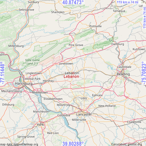
Lebanon GPS coordinates[2]
40° 20' 27.348" North, 76° 24' 40.86" West
| Map corner | latitude | longitude |
|---|---|---|
| Upper-left | 40.87473°, | -77.11448° |
| Center: | 40.34093°, | -76.41135° |
| Lower-right: | 39.80288°, | -75.70823° |
| Map W x H: | 119.2×119.2 km | = 74.1×74.1mi |
| max Lat: | 71.29058° ⇑42.8% North |
| Lebanon: | 40.34093° |
| min Lat: | ⇓57.2% South 19.06759° |
| min Long | Lebanon | max Long |
| -171.73463° | -76.41135° | -66.98998° |
| W 82.9%⇐ | ⇒17.1% E |
Elevation
Elevation of Lebanon is 147 m = 482 ft, and this is 147.8 m = 485 ft below average elevation for this country.
| Max E: |
3189 m = 10463 ft | 61.5% |
| Avg. | 294.8 m = 967 ft | |
| Lebanon | 147 m = 482 ft | |
Min E: |
-60 m = -197 ft | 38.5% |
See also: United States elevation on elevation.city.
Geographical zone
Lebanon is located in North temperate zone (between Tropic of Cancer and the Arctic Circle). Distance of this Northern Tropic circle is 1879.6 km =1167.9 mi to South.| Distance of | km | miles | from Lebanon |
|---|---|---|---|
| North Pole | 5521.6 | 3431 | to North |
| Arctic Circle | 2915.7 | 1811.7 | to North |
| Tropic Cancer | 1879.6 | 1167.9 | to South |
| Equator | 4485.5 | 2787.2 | to South |


Nearby cities:
15 places around Lebanon: (largest is in red/bold)
• Annville
8.9 km =5.5 mi,  261°
261°
• Avon
1.9 km =1.2 mi,  73°
73°
• Cleona
5.5 km =3.4 mi,  265°
265°
• Cornwall
7.5 km =4.7 mi,  176°
176°
• Fredericksburg
11.5 km =7.1 mi,  352°
352°
• Hebron
1 km =0.6 mi,  102°
102°
• Jonestown
9.9 km =6.2 mi,  324°
324°
• Lebanon South
1.5 km =0.9 mi,  163°
163°
• Myerstown
9.9 km =6.2 mi, 67°
• Pleasant Hill
2.6 km =1.6 mi, 258°
• Quentin
7.2 km =4.5 mi,  199°
199°
• Richland
13.1 km =8.1 mi,  81°
81°
• Rockwood
5.5 km =3.4 mi, 322°
• Sand Hill
2.7 km =1.7 mi, 320°
• Schaefferstown
11 km =6.8 mi,  115°
115°
Sources, notices
• [Note1] Compared only with cities in United States existing in our database
• [Src1] Map data: © OpenStreetMap contributors (CC-BY-SA)
• [Src2] Other city data from geonames.org with taken over terms of usage.
• [Src3] Geographical zone / Annual Mean Temperature by Robert A. Rohde @ Wikipedia
