Richland geodata
Richland (Pennsylvania) is a populated place; located in United States in America/New_York (GMT-4) time zone. With population of 1,560 people, there are 13436 cities with bigger population in this country. Compared to other cities in United States, 57.4% of cities are located further ↓South; 83.3% of cities are located further ←West and 60.9% of cities have higher elevation than Richland. Note1
Administrative division(s):
- Level 1: Pennsylvania
- Level 2: Lebanon County
- Level 3: Borough of Richland


Richland GPS coordinates[2]
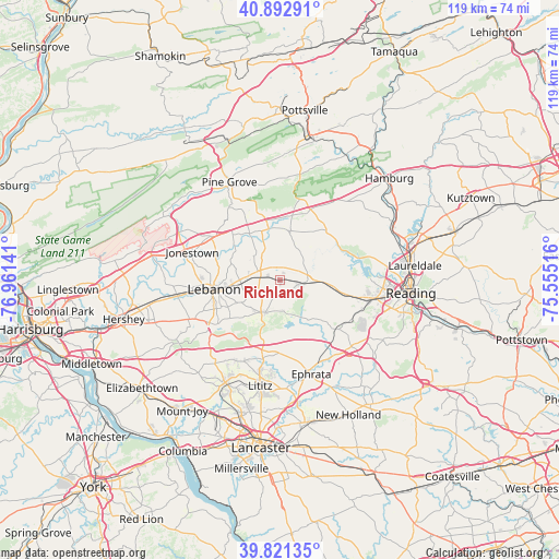
40° 21' 33.336" North, 76° 15' 29.808" West
| Map corner | latitude | longitude |
|---|---|---|
| Upper-left | 40.89291°, | -76.96141° |
| Center: | 40.35926°, | -76.25828° |
| Lower-right: | 39.82135°, | -75.55516° |
| Map W x H: | 119.1×119.1 km | = 74×74mi |
| max Lat: | 71.29058° ⇑42.6% North |
| Richland: | 40.35926° |
| min Lat: | ⇓57.4% South 19.06759° |
| min Long | Richland | max Long |
| -171.73463° | -76.25828° | -66.98998° |
| W 83.3%⇐ | ⇒16.7% E |
Elevation
Elevation of Richland is 150 m = 492 ft, and this is 144.8 m = 475 ft below average elevation for this country.
| Max E: |
3189 m = 10463 ft | 60.9% |
| Avg. | 294.8 m = 967 ft | |
| Richland | 150 m = 492 ft | |
Min E: |
-60 m = -197 ft | 39.1% |
See also: United States elevation on elevation.city.
Geographical zone
Richland is located in North temperate zone (between Tropic of Cancer and the Arctic Circle). Distance of this Northern Tropic circle is 1881.6 km =1169.2 mi to South.| Distance of | km | miles | from Richland |
|---|---|---|---|
| North Pole | 5519.5 | 3429.7 | to North |
| Arctic Circle | 2913.6 | 1810.4 | to North |
| Tropic Cancer | 1881.6 | 1169.2 | to South |
| Equator | 4487.5 | 2788.4 | to South |


Nearby cities:
15 places around Richland: (largest is in red/bold)
• Avon
11.3 km =7 mi,  262°
262°
• Bernville
14.9 km =9.3 mi,  56°
56°
• Brickerville
15.3 km =9.5 mi,  194°
194°
• Hebron
12.2 km =7.6 mi, 259°
• Hopeland
14 km =8.7 mi,  181°
181°
• Lebanon
13.1 km =8.1 mi, 261°
• Lebanon South
13 km =8.1 mi,  254°
254°
• Myerstown
4.1 km =2.5 mi,  294°
294°
• Newmanstown
4 km =2.5 mi,  105°
105°
• Robesonia
10.5 km =6.5 mi,  94°
94°
• Sand Hill
14.7 km =9.1 mi,  270°
270°
• Schaefferstown
7.4 km =4.6 mi,  204°
204°
• Schoeneck
14.9 km =9.3 mi,  151°
151°
• Stouchsburg
3.2 km =2 mi,  43°
43°
• Womelsdorf
6.3 km =3.9 mi, 87°
Sources, notices
• [Note1] Compared only with cities in United States existing in our database
• [Src1] Map data: © OpenStreetMap contributors (CC-BY-SA)
• [Src2] Other city data from geonames.org with taken over terms of usage.
• [Src3] Geographical zone / Annual Mean Temperature by Robert A. Rohde @ Wikipedia
