Lime Ridge geodata
Lime Ridge (Pennsylvania) is a populated place; located in United States in America/New_York (GMT-4) time zone. With population of 890 people, there are 17039 cities with bigger population in this country. Compared to other cities in United States, 66.2% of cities are located further ↓South; 83.1% of cities are located further ←West and 59.9% of cities have higher elevation than Lime Ridge. Note1
Administrative division(s):
- Level 1: Pennsylvania
- Level 2: Columbia County
- Level 3: Township of South Centre


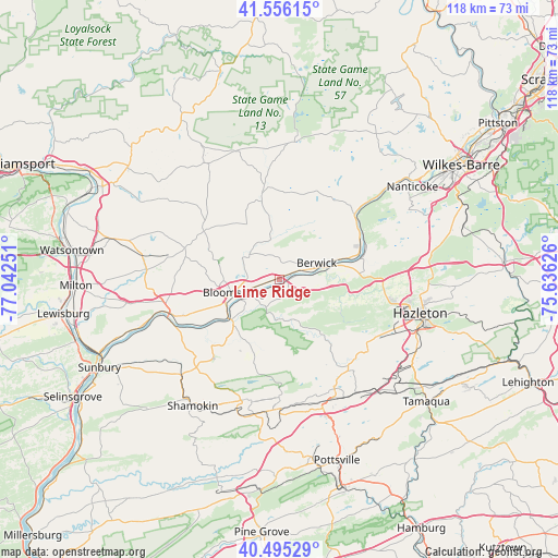
Lime Ridge GPS coordinates[2]
41° 1' 40.296" North, 76° 20' 21.768" West
| Map corner | latitude | longitude |
|---|---|---|
| Upper-left | 41.55615°, | -77.04251° |
| Center: | 41.02786°, | -76.33938° |
| Lower-right: | 40.49529°, | -75.63626° |
| Map W x H: | 118×118 km | = 73.3×73.3mi |
| max Lat: | 71.29058° ⇑33.8% North |
| Lime Ridge: | 41.02786° |
| min Lat: | ⇓66.2% South 19.06759° |
| min Long | Lime Ridge | max Long |
| -171.73463° | -76.33938° | -66.98998° |
| W 83.1%⇐ | ⇒16.9% E |
Elevation
Elevation of Lime Ridge is 155 m = 509 ft, and this is 139.8 m = 459 ft below average elevation for this country.
| Max E: |
3189 m = 10463 ft | 59.9% |
| Avg. | 294.8 m = 967 ft | |
| Lime Ridge | 155 m = 509 ft | |
Min E: |
-60 m = -197 ft | 40.1% |
See also: United States elevation on elevation.city.
Geographical zone
Lime Ridge is located in North temperate zone (between Tropic of Cancer and the Arctic Circle). Distance of this Northern Tropic circle is 1956 km =1215.4 mi to South.| Distance of | km | miles | from Lime Ridge |
|---|---|---|---|
| North Pole | 5445.2 | 3383.5 | to North |
| Arctic Circle | 2839.3 | 1764.3 | to North |
| Tropic Cancer | 1956 | 1215.4 | to South |
| Equator | 4561.9 | 2834.6 | to South |


Nearby cities:
15 places around Lime Ridge: (largest is in red/bold)
• Almedia
3.8 km =2.4 mi,  247°
247°
• Benton
19 km =11.8 mi,  348°
348°
• Berwick
9.4 km =5.8 mi,  71°
71°
• Bloomsburg
10.1 km =6.3 mi, 254°
• Briar Creek
5.2 km =3.2 mi, 67°
• Catawissa
13.2 km =8.2 mi,  230°
230°
• East Berwick
10.5 km =6.5 mi, 68°
• Espy
6.4 km =4 mi, 247°
• Fernville
10.8 km =6.7 mi,  255°
255°
• Light Street
7.1 km =4.4 mi,  277°
277°
• Mifflinville
2.7 km =1.7 mi,  79°
79°
• Millville
19 km =11.8 mi,  302°
302°
• Nescopeck
10.3 km =6.4 mi, 74°
• Orangeville
8.4 km =5.2 mi,  311°
311°
• Ringtown
20.9 km =13 mi,  153°
153°
Sources, notices
• [Note1] Compared only with cities in United States existing in our database
• [Src1] Map data: © OpenStreetMap contributors (CC-BY-SA)
• [Src2] Other city data from geonames.org with taken over terms of usage.
• [Src3] Geographical zone / Annual Mean Temperature by Robert A. Rohde @ Wikipedia
