Red Lion geodata
Red Lion (Pennsylvania) is a populated place; located in United States in America/New_York (GMT-4) time zone. With population of 6,055 people, there are 6364 cities with bigger population in this country. Compared to other cities in United States, 58.7% of cities are located further ↓South; 85.2% of cities are located further ←West and 57.5% of cities have lower elevation than Red Lion. Note1
Administrative division(s):
- Level 1: Pennsylvania
- Level 2: Berks County
- Level 3: Township of Longswamp


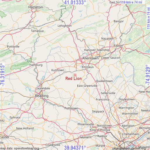
Red Lion GPS coordinates[2]
40° 28' 50.34" North, 75° 36' 57.672" West
| Map corner | latitude | longitude |
|---|---|---|
| Upper-left | 41.01333°, | -76.31915° |
| Center: | 40.48065°, | -75.61602° |
| Lower-right: | 39.94371°, | -74.9129° |
| Map W x H: | 118.9×118.9 km | = 73.9×73.9mi |
| max Lat: | 71.29058° ⇑41.3% North |
| Red Lion: | 40.48065° |
| min Lat: | ⇓58.7% South 19.06759° |
| min Long | Red Lion | max Long |
| -171.73463° | -75.61602° | -66.98998° |
| W 85.2%⇐ | ⇒14.8% E |
Elevation
Elevation of Red Lion is 228 m = 748 ft, and this is 66.8 m = 219 ft below average elevation for this country.
| Max E: |
3189 m = 10463 ft | 42.5% |
| Avg. | 294.8 m = 967 ft | |
| Red Lion | 228 m = 748 ft | |
Min E: |
-60 m = -197 ft | 57.5% |
See also: United States elevation on elevation.city.
Geographical zone
Red Lion is located in North temperate zone (between Tropic of Cancer and the Arctic Circle). Distance of this Northern Tropic circle is 1895.1 km =1177.6 mi to South.| Distance of | km | miles | from Red Lion |
|---|---|---|---|
| North Pole | 5506 | 3421.3 | to North |
| Arctic Circle | 2900.1 | 1802 | to North |
| Tropic Cancer | 1895.1 | 1177.6 | to South |
| Equator | 4501 | 2796.8 | to South |


Nearby cities:
15 places around Red Lion: (largest is in red/bold)
• Alburtis
3.5 km =2.2 mi,  18°
18°
• Ancient Oaks
7.7 km =4.8 mi, 16°
• Bally
9 km =5.6 mi,  164°
164°
• Bechtelsville
12 km =7.5 mi,  185°
185°
• Breinigsville
6.4 km =4 mi,  348°
348°
• Dorneyville
13.3 km =8.3 mi,  37°
37°
• East Greenville
12.7 km =7.9 mi,  130°
130°
• Emmaus
12 km =7.5 mi,  56°
56°
• Hereford
6.4 km =4 mi,  122°
122°
• Macungie
6.5 km =4 mi,  52°
52°
• Mertztown
5 km =3.1 mi,  303°
303°
• New Jerusalem
11.7 km =7.3 mi,  251°
251°
• Topton
7.6 km =4.7 mi,  289°
289°
• Trexlertown
7.6 km =4.7 mi,  6°
6°
• Wescosville
11 km =6.8 mi,  29°
29°
Sources, notices
• [Note1] Compared only with cities in United States existing in our database
• [Src1] Map data: © OpenStreetMap contributors (CC-BY-SA)
• [Src2] Other city data from geonames.org with taken over terms of usage.
• [Src3] Geographical zone / Annual Mean Temperature by Robert A. Rohde @ Wikipedia
