Rural Valley geodata
Rural Valley (Pennsylvania) is a populated place; located in United States in America/New_York (GMT-4) time zone. With population of 850 people, there are 17359 cities with bigger population in this country. Compared to other cities in United States, 63.2% of cities are located further ↓South; 75.2% of cities are located further ←West and 79.2% of cities have lower elevation than Rural Valley. Note1
Administrative division(s):
- Level 1: Pennsylvania
- Level 2: Armstrong County
- Level 3: Borough of Rural Valley


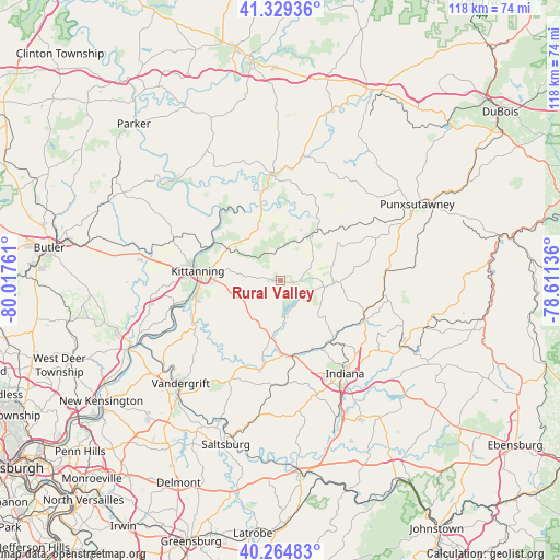
Rural Valley GPS coordinates[2]
40° 47' 57.228" North, 79° 18' 52.128" West
| Map corner | latitude | longitude |
|---|---|---|
| Upper-left | 41.32936°, | -80.01761° |
| Center: | 40.79923°, | -79.31448° |
| Lower-right: | 40.26483°, | -78.61136° |
| Map W x H: | 118.4×118.4 km | = 73.6×73.6mi |
| max Lat: | 71.29058° ⇑36.8% North |
| Rural Valley: | 40.79923° |
| min Lat: | ⇓63.2% South 19.06759° |
| min Long | Rural Valley | max Long |
| -171.73463° | -79.31448° | -66.98998° |
| W 75.2%⇐ | ⇒24.8% E |
Elevation
Elevation of Rural Valley is 346 m = 1135 ft, and this is 51.2 m = 168 ft above average elevation for this country.
| Max E: |
3189 m = 10463 ft | 20.8% |
| Rural Valley | 346 m 1135 ft | |
| Avg. | 294.8 m = 967 ft | |
Min E: |
-60 m = -197 ft | 79.2% |
See also: United States elevation on elevation.city.
Geographical zone
Rural Valley is located in North temperate zone (between Tropic of Cancer and the Arctic Circle). Distance of this Northern Tropic circle is 1930.5 km =1199.6 mi to South.| Distance of | km | miles | from Rural Valley |
|---|---|---|---|
| North Pole | 5470.6 | 3399.3 | to North |
| Arctic Circle | 2864.7 | 1780 | to North |
| Tropic Cancer | 1930.5 | 1199.6 | to South |
| Equator | 4536.4 | 2818.8 | to South |


Nearby cities:
15 places around Rural Valley: (largest is in red/bold)
• Chevy Chase Heights
23.1 km =14.4 mi,  141°
141°
• Clymer
29.4 km =18.3 mi,  119°
119°
• Dayton
10.9 km =6.8 mi,  34°
34°
• Ford City
18.4 km =11.4 mi,  260°
260°
• Indiana
24 km =14.9 mi,  145°
145°
• Jacksonville
28.9 km =18 mi,  174°
174°
• Kittanning
17.6 km =10.9 mi,  276°
276°
• Lenape Heights
17.8 km =11.1 mi, 257°
• Millville
24.2 km =15 mi,  2°
2°
• New Bethlehem
22.6 km =14 mi,  356°
356°
• New Salem
21.8 km =13.5 mi,  15°
15°
• Orchard Hills
29.9 km =18.6 mi,  217°
217°
• West Hills
19.4 km =12.1 mi, 278°
• West Kittanning
18.1 km =11.2 mi,  273°
273°
• Worthington
27.1 km =16.8 mi, 279°
Sources, notices
• [Note1] Compared only with cities in United States existing in our database
• [Src1] Map data: © OpenStreetMap contributors (CC-BY-SA)
• [Src2] Other city data from geonames.org with taken over terms of usage.
• [Src3] Geographical zone / Annual Mean Temperature by Robert A. Rohde @ Wikipedia
