Yeagertown geodata
Yeagertown (Pennsylvania) is a populated place; located in United States in America/New_York (GMT-4) time zone. With population of 1,050 people, there are 15959 cities with bigger population in this country. Compared to other cities in United States, 60.7% of cities are located further ↓South; 78.7% of cities are located further ←West and 55.3% of cities have higher elevation than Yeagertown. Note1
Administrative division(s):
- Level 1: Pennsylvania
- Level 2: Mifflin County
- Level 3: Township of Derry


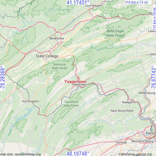
Yeagertown GPS coordinates[2]
40° 38' 35.268" North, 77° 34' 49.98" West
| Map corner | latitude | longitude |
|---|---|---|
| Upper-left | 41.17451°, | -78.28368° |
| Center: | 40.64313°, | -77.58055° |
| Lower-right: | 40.10748°, | -76.87743° |
| Map W x H: | 118.6×118.6 km | = 73.7×73.7mi |
| max Lat: | 71.29058° ⇑39.3% North |
| Yeagertown: | 40.64313° |
| min Lat: | ⇓60.7% South 19.06759° |
| min Long | Yeagertown | max Long |
| -171.73463° | -77.58055° | -66.98998° |
| W 78.7%⇐ | ⇒21.3% E |
Elevation
Elevation of Yeagertown is 179 m = 587 ft, and this is 115.8 m = 380 ft below average elevation for this country.
| Max E: |
3189 m = 10463 ft | 55.3% |
| Avg. | 294.8 m = 967 ft | |
| Yeagertown | 179 m = 587 ft | |
Min E: |
-60 m = -197 ft | 44.7% |
See also: United States elevation on elevation.city.
Geographical zone
Yeagertown is located in North temperate zone (between Tropic of Cancer and the Arctic Circle). Distance of this Northern Tropic circle is 1913.2 km =1188.8 mi to South.| Distance of | km | miles | from Yeagertown |
|---|---|---|---|
| North Pole | 5488 | 3410.1 | to North |
| Arctic Circle | 2882.1 | 1790.9 | to North |
| Tropic Cancer | 1913.2 | 1188.8 | to South |
| Equator | 4519.1 | 2808 | to South |


Nearby cities:
15 places around Yeagertown: (largest is in red/bold)
• Allensville
23.2 km =14.4 mi,  239°
239°
• Belleville
12.9 km =8 mi,  250°
250°
• Boalsburg
23.2 km =14.4 mi,  309°
309°
• Burnham
1.1 km =0.7 mi,  116°
116°
• Church Hill
4.6 km =2.9 mi,  340°
340°
• Highland Park
2.7 km =1.7 mi,  156°
156°
• Juniata Terrace
6.4 km =4 mi,  178°
178°
• Lewistown
4.9 km =3 mi,  170°
170°
• McClure
23.5 km =14.6 mi,  72°
72°
• Mifflin
17.1 km =10.6 mi, 118°
• Mifflintown
17.5 km =10.9 mi, 117°
• Milroy
7.9 km =4.9 mi,  353°
353°
• Port Royal
20.5 km =12.7 mi,  126°
126°
• Reedsville
2.7 km =1.7 mi,  330°
330°
• Strodes Mills
12.9 km =8 mi,  217°
217°
Sources, notices
• [Note1] Compared only with cities in United States existing in our database
• [Src1] Map data: © OpenStreetMap contributors (CC-BY-SA)
• [Src2] Other city data from geonames.org with taken over terms of usage.
• [Src3] Geographical zone / Annual Mean Temperature by Robert A. Rohde @ Wikipedia
