Woonsocket geodata
Woonsocket (Rhode Island) is a populated place; located in United States in America/New_York (GMT-4) time zone. With population of 41,475 people, there are 1157 cities with bigger population in this country. Compared to other cities in United States, 75.7% of cities are located further ↓South; 96.6% of cities are located further ←West and 78.2% of cities have higher elevation than Woonsocket. Note1
Administrative division(s):
- Level 1: Rhode Island
- Level 2: Providence County
- Level 3: City of Woonsocket


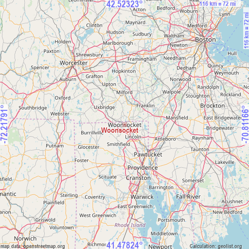
Woonsocket GPS coordinates[2]
42° 0' 10.368" North, 71° 30' 53.208" West
| Map corner | latitude | longitude |
|---|---|---|
| Upper-left | 42.52323°, | -72.21791° |
| Center: | 42.00288°, | -71.51478° |
| Lower-right: | 41.47824°, | -70.81166° |
| Map W x H: | 116.2×116.2 km | = 72.2×72.2mi |
| max Lat: | 71.29058° ⇑24.3% North |
| Woonsocket: | 42.00288° |
| min Lat: | ⇓75.7% South 19.06759° |
| min Long | Woonsocket | max Long |
| -171.73463° | -71.51478° | -66.98998° |
| W 96.6%⇐ | ⇒3.4% E |
Elevation
Elevation of Woonsocket is 55 m = 180 ft, and this is 239.8 m = 787 ft below average elevation for this country.
| Max E: |
3189 m = 10463 ft | 78.2% |
| Avg. | 294.8 m = 967 ft | |
| Woonsocket | 55 m = 180 ft | |
Min E: |
-60 m = -197 ft | 21.8% |
See also: Woonsocket elevation on elevation.city.
Geographical zone
Woonsocket is located in North temperate zone (between Tropic of Cancer and the Arctic Circle). Distance of this Northern Tropic circle is 2064.4 km =1282.8 mi to South.| Distance of | km | miles | from Woonsocket |
|---|---|---|---|
| North Pole | 5336.8 | 3316.1 | to North |
| Arctic Circle | 2730.9 | 1696.9 | to North |
| Tropic Cancer | 2064.4 | 1282.8 | to South |
| Equator | 4670.3 | 2902 | to South |


Nearby cities:
15 places around Woonsocket: (largest is in red/bold)
• Bellingham
9.9 km =6.2 mi,  19°
19°
• Blackstone
2.7 km =1.7 mi,  307°
307°
• Cumberland
7.9 km =4.9 mi,  120°
120°
• Cumberland Hill
5.1 km =3.2 mi,  128°
128°
• Franklin
13.2 km =8.2 mi,  47°
47°
• Harmony
14.5 km =9 mi,  207°
207°
• Harrisville
13.8 km =8.6 mi,  252°
252°
• Hopedale
14.4 km =8.9 mi,  351°
351°
• Lincoln
11.2 km =7 mi,  144°
144°
• Mendon
11.8 km =7.3 mi,  344°
344°
• Millville
6.1 km =3.8 mi,  296°
296°
• North Smithfield
4.9 km =3 mi,  215°
215°
• Smithfield
9.4 km =5.8 mi,  197°
197°
• Uxbridge
12.6 km =7.8 mi, 311°
• Valley Falls
14.8 km =9.2 mi, 136°
Sources, notices
• [Note1] Compared only with cities in United States existing in our database
• [Src1] Map data: © OpenStreetMap contributors (CC-BY-SA)
• [Src2] Other city data from geonames.org with taken over terms of usage.
• [Src3] Geographical zone / Annual Mean Temperature by Robert A. Rohde @ Wikipedia
