Armour geodata
Armour (South Dakota) is a seat of a second-order administrative division; located in United States in America/Chicago (GMT-5) time zone. With population of 686 people, there are 18824 cities with bigger population in this country. Compared to other cities in United States, 85.5% of cities are located further ↓South; 79.1% of cities are located further →East and 86.9% of cities have lower elevation than Armour. Note1


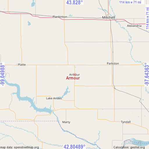
Armour GPS coordinates[2]
43° 19' 6.96" North, 98° 20' 48.3" West
| Map corner | latitude | longitude |
|---|---|---|
| Upper-left | 43.828°, | -99.04988° |
| Center: | 43.3186°, | -98.34675° |
| Lower-right: | 42.80489°, | -97.64363° |
| Map W x H: | 113.8×113.8 km | = 70.7×70.7mi |
| max Lat: | 71.29058° ⇑14.5% North |
| Armour: | 43.3186° |
| min Lat: | ⇓85.5% South 19.06759° |
| min Long | Armour | max Long |
| -171.73463° | -98.34675° | -66.98998° |
| W 20.9%⇐ | ⇒79.1% E |
Elevation
Elevation of Armour is 465 m = 1526 ft, and this is 170.2 m = 558 ft above average elevation for this country.
| Max E: |
3189 m = 10463 ft | 13.1% |
| Armour | 465 m 1526 ft | |
| Avg. | 294.8 m = 967 ft | |
Min E: |
-60 m = -197 ft | 86.9% |
See also: United States elevation on elevation.city.
Geographical zone
Armour is located in North temperate zone (between Tropic of Cancer and the Arctic Circle). Distance of this Northern Tropic circle is 2210.7 km =1373.7 mi to South.| Distance of | km | miles | from Armour |
|---|---|---|---|
| North Pole | 5190.5 | 3225.2 | to North |
| Arctic Circle | 2584.6 | 1606 | to North |
| Tropic Cancer | 2210.7 | 1373.7 | to South |
| Equator | 4816.6 | 2992.9 | to South |


Nearby cities:
15 places around Armour: (largest is in red/bold)
• Alexandria
58.8 km =36.5 mi,  50°
50°
• Avon
41.9 km =26 mi,  146°
146°
• Butte
60.9 km =37.8 mi,  222°
222°
• Corsica
12.8 km =8 mi,  337°
337°
• Lake Andes
24 km =14.9 mi, 221°
• Menno
62.9 km =39.1 mi,  98°
98°
• Mitchell
50.4 km =31.3 mi,  30°
30°
• Olivet
55 km =34.2 mi, 99°
• Parkston
30.7 km =19.1 mi,  73°
73°
• Plankinton
45.5 km =28.3 mi,  345°
345°
• Platte
41 km =25.5 mi,  280°
280°
• Scotland
54.3 km =33.7 mi,  110°
110°
• Tripp
32.5 km =20.2 mi, 108°
• Tyndall
53.4 km =33.2 mi,  132°
132°
• Wagner
26.9 km =16.7 mi,  170°
170°
Sources, notices
• [Note1] Compared only with cities in United States existing in our database
• [Src1] Map data: © OpenStreetMap contributors (CC-BY-SA)
• [Src2] Other city data from geonames.org with taken over terms of usage.
• [Src3] Geographical zone / Annual Mean Temperature by Robert A. Rohde @ Wikipedia
