Tyndall geodata
Tyndall (South Dakota) is a seat of a second-order administrative division; located in United States in America/Chicago (GMT-5) time zone. With population of 1,049 people, there are 15968 cities with bigger population in this country. Compared to other cities in United States, 83.2% of cities are located further ↓South; 78.2% of cities are located further →East and 85.5% of cities have lower elevation than Tyndall. Note1
Administrative division(s):
- Level 1: South Dakota
- Level 2: Bon Homme County
- Level 3: City of Tyndall


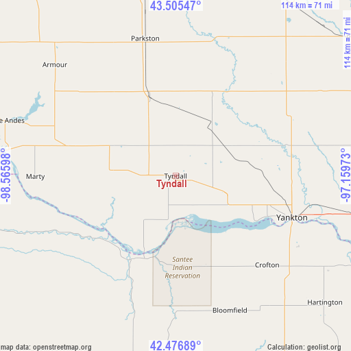
Tyndall GPS coordinates[2]
42° 59' 35.988" North, 97° 51' 46.26" West
| Map corner | latitude | longitude |
|---|---|---|
| Upper-left | 43.50547°, | -98.56598° |
| Center: | 42.99333°, | -97.86285° |
| Lower-right: | 42.47689°, | -97.15973° |
| Map W x H: | 114.4×114.4 km | = 71.1×71.1mi |
| max Lat: | 71.29058° ⇑16.8% North |
| Tyndall: | 42.99333° |
| min Lat: | ⇓83.2% South 19.06759° |
| min Long | Tyndall | max Long |
| -171.73463° | -97.86285° | -66.98998° |
| W 21.8%⇐ | ⇒78.2% E |
Elevation
Elevation of Tyndall is 433 m = 1421 ft, and this is 138.2 m = 453 ft above average elevation for this country.
| Max E: |
3189 m = 10463 ft | 14.5% |
| Tyndall | 433 m 1421 ft | |
| Avg. | 294.8 m = 967 ft | |
Min E: |
-60 m = -197 ft | 85.5% |
See also: United States elevation on elevation.city.
Geographical zone
Tyndall is located in North temperate zone (between Tropic of Cancer and the Arctic Circle). Distance of this Northern Tropic circle is 2174.5 km =1351.2 mi to South.| Distance of | km | miles | from Tyndall |
|---|---|---|---|
| North Pole | 5226.7 | 3247.7 | to North |
| Arctic Circle | 2620.8 | 1628.5 | to North |
| Tropic Cancer | 2174.5 | 1351.2 | to South |
| Equator | 4780.4 | 2970.4 | to South |


Nearby cities:
15 places around Tyndall: (largest is in red/bold)
• Armour
53.4 km =33.2 mi,  312°
312°
• Avon
16.1 km =10 mi,  274°
274°
• Bloomfield
47.3 km =29.4 mi,  157°
157°
• Center
42.7 km =26.5 mi,  181°
181°
• Crofton
42 km =26.1 mi,  134°
134°
• Freeman
52.8 km =32.8 mi,  40°
40°
• Menno
35.9 km =22.3 mi, 40°
• Olivet
31.4 km =19.5 mi,  28°
28°
• Parkston
46.1 km =28.6 mi,  347°
347°
• Scotland
21 km =13 mi, 34°
• Springfield
15.7 km =9.8 mi,  190°
190°
• Tripp
27.1 km =16.8 mi,  342°
342°
• Verdigre
46.2 km =28.7 mi,  197°
197°
• Wagner
36.3 km =22.6 mi,  285°
285°
• Yankton
40.3 km =25 mi,  109°
109°
Sources, notices
• [Note1] Compared only with cities in United States existing in our database
• [Src1] Map data: © OpenStreetMap contributors (CC-BY-SA)
• [Src2] Other city data from geonames.org with taken over terms of usage.
• [Src3] Geographical zone / Annual Mean Temperature by Robert A. Rohde @ Wikipedia
