Fort Thompson geodata
Fort Thompson (South Dakota) is a populated place; located in United States in America/Chicago (GMT-5) time zone. With population of 1,282 people, there are 14675 cities with bigger population in this country. Compared to other cities in United States, 88.7% of cities are located further ↓South; 80.3% of cities are located further →East and 85.8% of cities have lower elevation than Fort Thompson. Note1
Administrative division(s):
- Level 1: South Dakota
- Level 2: Buffalo County
- Level 3: Unorganized Territory of Crow Creek


Fort Thompson GPS coordinates[2]
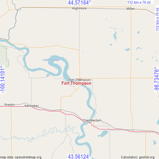
44° 4' 6.96" North, 99° 26' 16.368" West
| Map corner | latitude | longitude |
|---|---|---|
| Upper-left | 44.57164°, | -100.14101° |
| Center: | 44.0686°, | -99.43788° |
| Lower-right: | 43.56124°, | -98.73476° |
| Map W x H: | 112.3×112.3 km | = 69.8×69.8mi |
| max Lat: | 71.29058° ⇑11.3% North |
| Fort Thompson: | 44.0686° |
| min Lat: | ⇓88.7% South 19.06759° |
| min Long | Fort Thompson | max Long |
| -171.73463° | -99.43788° | -66.98998° |
| W 19.7%⇐ | ⇒80.3% E |
Elevation
Elevation of Fort Thompson is 439 m = 1440 ft, and this is 144.2 m = 473 ft above average elevation for this country.
| Max E: |
3189 m = 10463 ft | 14.2% |
| Fort Thompson | 439 m 1440 ft | |
| Avg. | 294.8 m = 967 ft | |
Min E: |
-60 m = -197 ft | 85.8% |
See also: United States elevation on elevation.city.
Geographical zone
Fort Thompson is located in North temperate zone (between Tropic of Cancer and the Arctic Circle). Distance of this Northern Tropic circle is 2294.1 km =1425.5 mi to South.| Distance of | km | miles | from Fort Thompson |
|---|---|---|---|
| North Pole | 5107.1 | 3173.4 | to North |
| Arctic Circle | 2501.2 | 1554.2 | to North |
| Tropic Cancer | 2294.1 | 1425.5 | to South |
| Equator | 4900 | 3044.7 | to South |


Nearby cities:
15 places around Fort Thompson: (largest is in red/bold)
• Chamberlain
29.9 km =18.6 mi,  163°
163°
• Fort Pierre
81 km =50.3 mi,  293°
293°
• Highmore
50.3 km =31.3 mi,  359°
359°
• Kennebec
38.6 km =24 mi,  241°
241°
• Kimball
52.5 km =32.6 mi,  132°
132°
• Lower Brule
11.5 km =7.1 mi,  275°
275°
• Miller
61.5 km =38.2 mi,  35°
35°
• Onida
86.6 km =53.8 mi,  325°
325°
• Pierre
80 km =49.7 mi, 294°
• Plankinton
85.8 km =53.3 mi,  117°
117°
• Platte
89.5 km =55.6 mi,  147°
147°
• Presho
52.7 km =32.7 mi,  250°
250°
• Wessington Springs
69.4 km =43.1 mi,  89°
89°
• Winner
84 km =52.2 mi,  203°
203°
• Woonsocket
92.9 km =57.7 mi, 91°
Sources, notices
• [Note1] Compared only with cities in United States existing in our database
• [Src1] Map data: © OpenStreetMap contributors (CC-BY-SA)
• [Src2] Other city data from geonames.org with taken over terms of usage.
• [Src3] Geographical zone / Annual Mean Temperature by Robert A. Rohde @ Wikipedia
