Kennebec geodata
Kennebec (South Dakota) is a seat of a second-order administrative division; located in United States in America/Chicago (GMT-5) time zone. With population of 260 people, there are 20987 cities with bigger population in this country. Compared to other cities in United States, 88% of cities are located further ↓South; 80.6% of cities are located further →East and 88.2% of cities have lower elevation than Kennebec. Note1


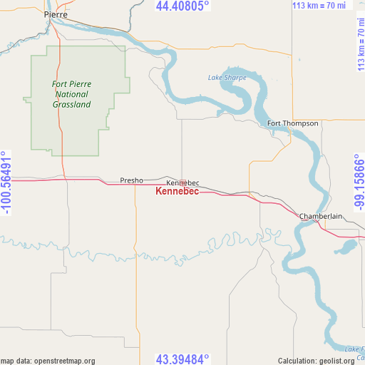
Kennebec GPS coordinates[2]
43° 54' 12.96" North, 99° 51' 42.408" West
| Map corner | latitude | longitude |
|---|---|---|
| Upper-left | 44.40805°, | -100.56491° |
| Center: | 43.9036°, | -99.86178° |
| Lower-right: | 43.39484°, | -99.15866° |
| Map W x H: | 112.7×112.7 km | = 70×70mi |
| max Lat: | 71.29058° ⇑12% North |
| Kennebec: | 43.9036° |
| min Lat: | ⇓88% South 19.06759° |
| min Long | Kennebec | max Long |
| -171.73463° | -99.86178° | -66.98998° |
| W 19.4%⇐ | ⇒80.6% E |
Elevation
Elevation of Kennebec is 514 m = 1686 ft, and this is 219.2 m = 719 ft above average elevation for this country.
| Max E: |
3189 m = 10463 ft | 11.8% |
| Kennebec | 514 m 1686 ft | |
| Avg. | 294.8 m = 967 ft | |
Min E: |
-60 m = -197 ft | 88.2% |
See also: United States elevation on elevation.city.
Geographical zone
Kennebec is located in North temperate zone (between Tropic of Cancer and the Arctic Circle). Distance of this Northern Tropic circle is 2275.7 km =1414.1 mi to South.| Distance of | km | miles | from Kennebec |
|---|---|---|---|
| North Pole | 5125.4 | 3184.8 | to North |
| Arctic Circle | 2519.6 | 1565.6 | to North |
| Tropic Cancer | 2275.7 | 1414.1 | to South |
| Equator | 4881.6 | 3033.3 | to South |


Nearby cities:
15 places around Kennebec: (largest is in red/bold)
• Antelope
91 km =56.5 mi,  222°
222°
• Burke
92.4 km =57.4 mi,  150°
150°
• Chamberlain
43.8 km =27.2 mi,  103°
103°
• Fort Pierre
64.6 km =40.1 mi,  320°
320°
• Fort Thompson
38.6 km =24 mi,  61°
61°
• Gregory
82.3 km =51.1 mi,  155°
155°
• Highmore
76.4 km =47.5 mi,  25°
25°
• Kimball
74.5 km =46.3 mi, 103°
• Lower Brule
29.7 km =18.5 mi,  49°
49°
• Murdo
68.2 km =42.4 mi,  268°
268°
• Onida
90.8 km =56.4 mi,  350°
350°
• Pierre
64.8 km =40.3 mi, 322°
• Presho
15.8 km =9.8 mi, 272°
• White River
80.2 km =49.8 mi,  242°
242°
• Winner
58.6 km =36.4 mi,  179°
179°
Sources, notices
• [Note1] Compared only with cities in United States existing in our database
• [Src1] Map data: © OpenStreetMap contributors (CC-BY-SA)
• [Src2] Other city data from geonames.org with taken over terms of usage.
• [Src3] Geographical zone / Annual Mean Temperature by Robert A. Rohde @ Wikipedia
