Howard geodata
Howard (South Dakota) is a seat of a second-order administrative division; located in United States in America/Chicago (GMT-5) time zone. With population of 790 people, there are 17900 cities with bigger population in this country. Compared to other cities in United States, 88.4% of cities are located further ↓South; 77.2% of cities are located further →East and 87.3% of cities have lower elevation than Howard. Note1


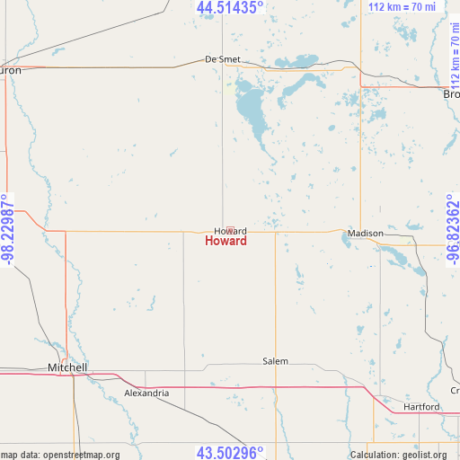
Howard GPS coordinates[2]
44° 0' 38.916" North, 97° 31' 36.264" West
| Map corner | latitude | longitude |
|---|---|---|
| Upper-left | 44.51435°, | -98.22987° |
| Center: | 44.01081°, | -97.52674° |
| Lower-right: | 43.50296°, | -96.82362° |
| Map W x H: | 112.5×112.5 km | = 69.9×69.9mi |
| max Lat: | 71.29058° ⇑11.6% North |
| Howard: | 44.01081° |
| min Lat: | ⇓88.4% South 19.06759° |
| min Long | Howard | max Long |
| -171.73463° | -97.52674° | -66.98998° |
| W 22.8%⇐ | ⇒77.2% E |
Elevation
Elevation of Howard is 479 m = 1572 ft, and this is 184.2 m = 604 ft above average elevation for this country.
| Max E: |
3189 m = 10463 ft | 12.7% |
| Howard | 479 m 1572 ft | |
| Avg. | 294.8 m = 967 ft | |
Min E: |
-60 m = -197 ft | 87.3% |
See also: United States elevation on elevation.city.
Geographical zone
Howard is located in North temperate zone (between Tropic of Cancer and the Arctic Circle). Distance of this Northern Tropic circle is 2287.6 km =1421.4 mi to South.| Distance of | km | miles | from Howard |
|---|---|---|---|
| North Pole | 5113.5 | 3177.4 | to North |
| Arctic Circle | 2507.6 | 1558.1 | to North |
| Tropic Cancer | 2287.6 | 1421.4 | to South |
| Equator | 4893.5 | 3040.7 | to South |


Nearby cities:
15 places around Howard: (largest is in red/bold)
• Alexandria
44.7 km =27.8 mi,  207°
207°
• Arlington
50.3 km =31.3 mi,  38°
38°
• Brookings
67 km =41.6 mi,  60°
60°
• Canistota
49.7 km =30.9 mi,  157°
157°
• Colman
57.1 km =35.5 mi,  93°
93°
• Colton
54.1 km =33.6 mi,  117°
117°
• De Smet
41.9 km =26 mi,  357°
357°
• Hartford
63.7 km =39.6 mi,  132°
132°
• Humboldt
54.5 km =33.9 mi,  138°
138°
• Lake Preston
41 km =25.5 mi,  16°
16°
• Madison
33 km =20.5 mi, 90°
• Mitchell
52.4 km =32.6 mi,  230°
230°
• Salem
33.7 km =20.9 mi, 160°
• Volga
59.2 km =36.8 mi,  54°
54°
• Woonsocket
60.1 km =37.3 mi,  274°
274°
Sources, notices
• [Note1] Compared only with cities in United States existing in our database
• [Src1] Map data: © OpenStreetMap contributors (CC-BY-SA)
• [Src2] Other city data from geonames.org with taken over terms of usage.
• [Src3] Geographical zone / Annual Mean Temperature by Robert A. Rohde @ Wikipedia
